Nor'easter arrives in Boston area this weekend. Forecast maps show highest impacts in Massachusetts.
An early fall nor'easter is starting to take shape and destined to make a mess of our weekend.
The WBZ Weather Team is highlighting both Saturday and Sunday as NEXT Weather Alert days for a variety of potential impacts from wind to flooding to erosion.
It is worth stressing that the most impactful weather this weekend will be along the immediate coastline. For the majority of those living away from the coast, say west of I-95, this will not be a memorable storm but more of an annoyance.
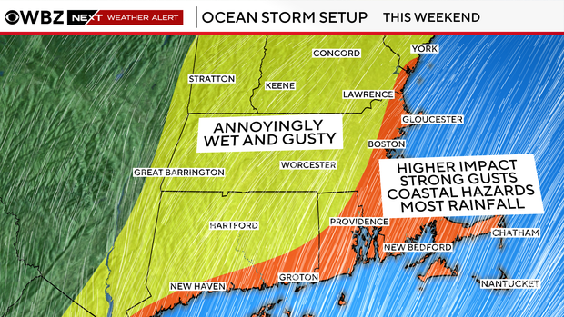
The heaviest rain, strongest winds and greatest risk of power outages are all expected to be within a few miles of the coast and over far southeastern Massachusetts.
Nor'easter timeline
This is going to be a long and drawn-out affair with more than 72 hours between the first drop and last drop of rain.
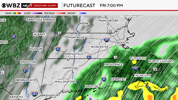
We expect some showers to arrive over southeastern Massachusetts during the late afternoon and into the evening on Friday.
They may move as far north as about Boston after dark, but we do not expect this initial rainfall to be very heavy.
Most of the rain on Friday night will be located south of the Mass. Pike and in particular, over the Cape and islands. Farther to the north, there will be a lot of dry air in place, so any rain would be very light and spotty.
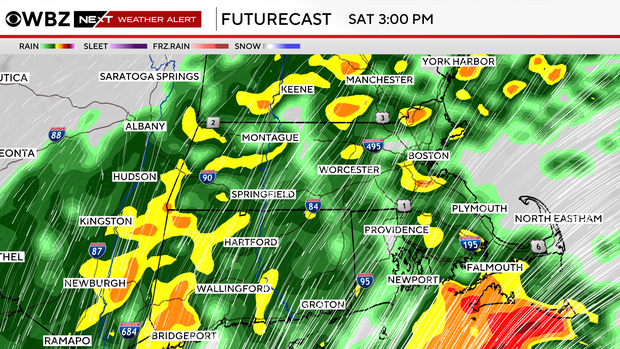
The rain will gradually increase in intensity and coverage during the day on Saturday. It will generally get heavier later in the day with pockets of downpours and isolated areas of localized flooding.
There will be waves or bands of heavy rain pinwheeling northward from the storm throughout Saturday night.
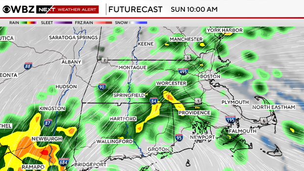
The rain will become somewhat lighter and spottier on Sunday. There will be off-and-on showers all day long with a few heavier, embedded downpours.
The storm only slowly starts to pull away, leaving us with mainly light, spotty showers. Western areas will likely begin to dry out late in the day.
It may take until sometime on Tuesday before most of eastern Massachusetts dries out and sees some sunshine.
How much rain from nor'easter?
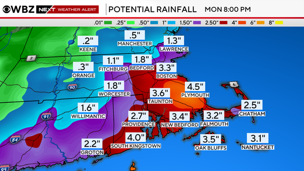
We expect most of the area to receive between 1 and 3 inches of rain from the nor'easter. Highest amounts closer to the coast and over southeastern Massachusetts.
Lower amounts west of I-95 and well inland.
There could be some isolated rainfall totals between 3 and 6 inches, again the best chance of this would be in far eastern areas.
Given the recent drought status, the area can certainly soak up a few inches of water. The trouble comes if we get heavy amounts in a short period of time. So, we will watch for some localized street flooding but do not expect any major river flooding.
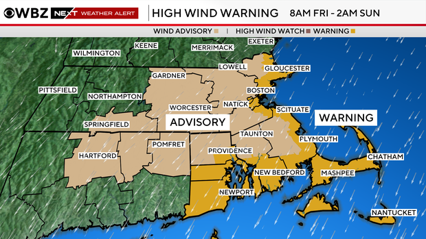
High Wind Warning
The National Weather Service has issued a High Wind Warning for coastal areas and a Wind Advisory for inland areas beginning at 8 a.m. Friday and lasting through 2 a.m. Sunday.
We expect northeast wind gusts to peak between 50 and 70 mph over Cape Ann, Cape Cod and the islands this weekend.
For the rest of the coast, we are forecasting 40-55 mph gusts.
West of I-95, less impactful winds in the neighborhood of 30-40 mph at worst.
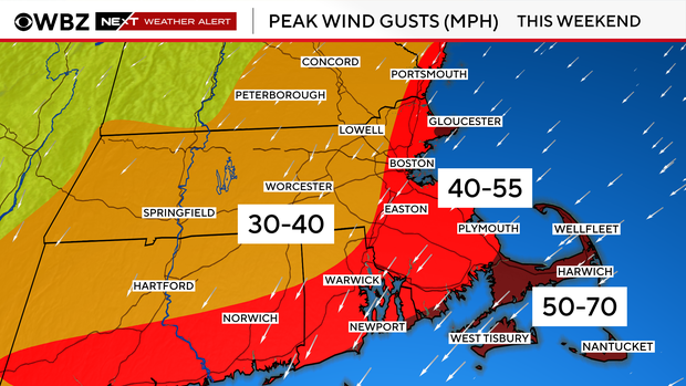
The winds will be at their worst Friday night through Saturday night and then slowly will taper and shift direction during Sunday and beyond.
There is a decent chance of some scattered power outages where the winds will be strongest (again, immediate coastline, Cape Cod, islands).
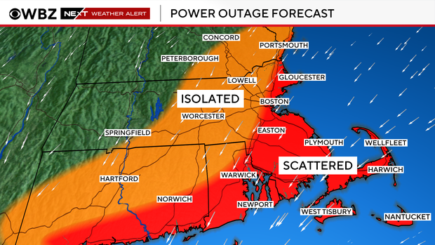
This would likely coincide with the timing of peak winds late Friday through late Saturday.
Coastal Flood Watch
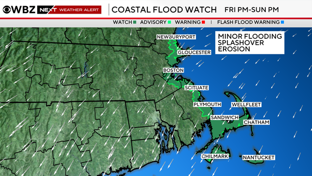
The National Weather Service has issued a Coastal Flood Watch from Friday p.m. through Sunday night for several high tide cycles.
Most of the coastal flooding should be minor with up to 1 foot of water inundation and some typical road closures right at the shoreline.
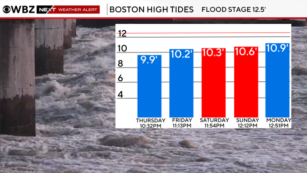
High tides on Friday and Saturday occur just before midnight. We are most concerned with those two tide cycles because that is when the strongest onshore winds will be.
Tides will continue to climb astronomically on Sunday and early next week. However, the wind will be changing direction and also decreasing by then.
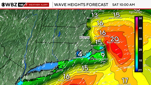
Wave heights at local beaches could reach as high as 8 to 12 feet with swells just offshore between 10 and 20 feet.
Again, the wave action will also peak from late Friday through Saturday.
As always, we urge that you stay tuned to frequent forecast updates from the entire WBZ-TV NEXT Weather team. We've got you covered.


