Snow And Sleet Hit Western Md. Mountains
Authorities say ice and sleet are making driving treacherous in the mountains of far western Maryland.
Watch CBS News
Authorities say ice and sleet are making driving treacherous in the mountains of far western Maryland.

The National Weather Service is reporting minor flooding along the Monocacay River near Frederick.

The rain spread across the state overnight and hasn't really stopped since. In fact, bands of heavy rain and thunderstorms have picked up through the day

It's a slow moving storm, but it's coming this way. Clouds started to come in late yesterday and then thickened up today, now the rain is moving into Maryland tonight.
The weather ups and downs continue, and today we are on the upside. Spring is in the air - at least for today. Sunshine and a southwesterly wind has warmed us up to low 60s this afternoon.
We did drop down to the teens overnight, forcing the untreated snowmelt to freeze up again. Now, with sunshine and temperatures topping out in the low 40s, the melting is underway again.
Each day is a completely different weather story right now. We go from near record warmth to damaging winds to snow. Yes, I just said (or wrote) snow, and it's coming our way.
Yesterday's front is gone, but we are still dealing with the winds from it. They have been gusting between 55-60 mph across most of the state today, which puts them in the tropical storm category.

The sun has provided some welcome warmth this week. But it's also packing a punch, triggered by the first big solar storm in years.
Despite clouds out there, we got all the way up to 52 degrees this afternoon. That makes it three days now with above average warmth.
It's been a cold winter so far. We were -4.1 degrees below average for December, which made it the 15th coldest December on record. Those records date back to 1872. January was another cold month, where we came in -2.1 degrees below average.
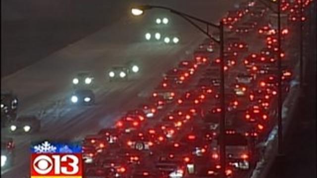
A snowstorm left Maryland crippled. Major highways were clogged with cars simply stuck not going anywhere. A tractor trailer crashed at I-83 and the Beltway—forcing some commuters to abandon their cars on the highway.
This has been an incredibly wild storm. I'll admit, I underestimated its strength. It really featured a little - no, make that a lot - of everything all around the state. But as of this writing at 10:30 p.m., the end is in sight.
A cold front passed north of us early this morning. There were clouds and even a few flurries with it, but what it really did was bring in a new round of cold air on gusty northwest winds.
We started out the day at 12 degrees and only went up to 25 degrees this afternoon. We are dropping right back into the teens and single digits overnight.
The cold air is here, now comes the next storm.
One round of snow is gone, but another could be on the way. One thing's for certain...the cold air is locked in for a while.

As a 'clipper' starts to dive southeastward and out of the Great Lakes today, there will be a tendency for any sun to fade behind increasing clouds.
After a holiday break from the cold, it's moving back into Maryland.
There is another storm on the way, but it is not getting here until later tomorrow. Ahead of it, the warmth has come flooding into the state.

A powerful winter storm lay a snow blanket from the South to the Northeast on Sunday, turning roads slick, stranding thousands of airline, train and bus passengers and putting a chill in retailers' day-after-Christmas sales.
Christmas day may start out partly sunny before clouds begin to increase ahead of the upper level feature associated with the current Midwest storm.
We missed one storm, but there are more lined up.
We are getting a brief break from the harsh cold, courtesy of the current storm, before the next round of Arctic air invades.

The snowflakes that fell on central Maryland on Friday were short lived, but they caused major problems on the roads. A hill in Owings Mills was so slick and icy that it brought vehicles to a standstill and caused a major roadblock.