WEATHER BLOG: Dry Weather Continues
An area of low pressure will reach a position near the Virginia coast by early tonight, but should have no direct impacts (other than generating some clouds) on our weather tonight or tomorrow. It can technically be called a 'coastal storm', but all of the rain and gusty winds associated with it will take place offshore...
So, the dry weather that the Eastern Region has experienced since the middle of last week will continue, and it appears that our chances for getting rain around here will be quite slim during much of this upcoming week. (See below for comments on something possible Wed. night/early Thurs.)
Therefore, the biggest challenges we'll be confronted should involve sky cover and temperatures on a day to day basis.
We've noticing on satellite imagery overnight that some high, thin clouds have been drifting through the coastal plain, while most of the lower, stratus clouds and dense fog have been confined to those places located closer to the central Appalachians, as well as in the Ohio Valley.
Well inland (especially north/west of I-95) is where our toughest temperature forecasts will be made today, because if there isn't sufficient mixing -- and the low clouds/fog never break, a few locations will fail to get out of the 30s, let alone it getting to 50 degrees or higher!!
At this time of year, with a very low sun angle, assuming clouds or fog will always break up is never a 'slam dunk'.
With a low pressure system located offshore late tonight and tomorrow, our weather will stay dry.
But, there will be times when the surface wind will have a light, easterly component. Based on this, our maximum temperature forecasts for tomorrow are approximately 2 or 3 degrees lower than today's. But Wednesday, a warm front is expected to move in from the south and west.
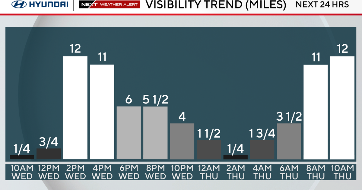
Therefore, our various forms of temperature guidance all point to a 'snapping back' on Wednesday, with temperatures on this day will be comparable to what we're anticipating today... This warm front could also bring a spotty shower to our area very late on Wednesday, Wednesday night or (especially in New England) early Thursday morning, but we would only get a couple hundredths of an inch of rain at the very most.
There isn't much more to comment on, except that the global models all imply that a ridge of high pressure in the upper atmosphere will be building over the eastern third of the nation Friday and Saturday. With this in mind, as long as clouds and fog don't play 'spoiler' roles, there will probably be enough of a surge of warm air occurring to push the temperature into the upper 50s and lower 60s next weekend. Get in the HOLIDAY SPIRIT, now -- just don't expect the weather to resemble anything indicating that winter is 'around the corner'.