A few showers later Sunday in Maryland before severe storms Monday

Happy Sunday, Maryland!
We'll watch out for some showers this evening and overnight, before a couple bouts of stronger storms are expected on Monday. A few may be severe.
Afternoon showers Sunday
Sunday started quiet with a mix of clouds and sunshine in the morning. Much of the day will be dry. A few spotty showers are expected in the afternoon before a higher risk for rain tonight.
Some of the overnight showers could be on the heavier side.
Today will also feature some gusty winds, similar to Saturday with gusts up to about 30 mph. Highs will be seasonably mild: 50s to near 60 degrees, but a little cooler in Harford and Cecil counties.
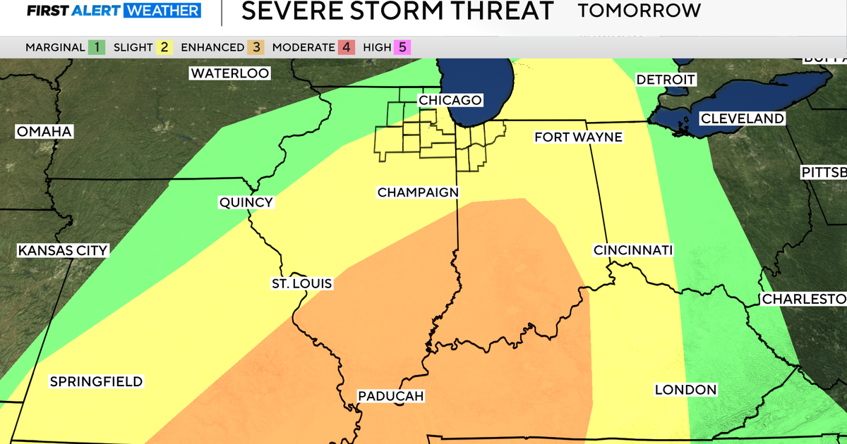
Severe storm threat Monday
Monday is a WJZ First Alert Weather Day.
As of Sunday morning, parts of Maryland are now under a level 4 out of 5 risk for severe weather. At this threat level, many of the storms we see have severe weather potential, instead of an isolated risk. Not every storm will be severe in every neighborhood, but every neighborhood should be prepared in case a storm pushes that threshold.
The last time any part of Maryland was under a level 4 risk was August 2023.
Our greatest threats from storms Monday, in order, are: damaging wind gusts, tornadoes and hail. While heavy rain and lightning are expected, those are not qualifiers for whether a storm is severe or not.
Monday will start out with some scattered showers and the risk for storms before daybreak. After the sun rises, our strong-to-possibly-severe storm risk will also rise.
A few storms could strengthen enough to produce severe weather late in the morning toward midday Monday. This will be out ahead of the main line of storms, which tracks through during the afternoon into the early evening.
The timing on the later storms appears to be between 2 p.m. and 7 p.m. The later storms during the afternoon and evening have the increased risk for rotation or tornadoes.
Colder air will rush in once the main line ahead of the cold front moves through. A few snowflakes are possible Monday evening behind the storms. Accumulations and impacts will be minimal, if anything at all.
St. Patrick's Day much colder
As mentioned above, colder air will quickly replace mild temperatures from Monday, which peak in the 60s to near 70 degrees.
You'll need to bring the cold weather gear back out on Tuesday. High temperatures will only reach the 30s to around 40. Breezy winds will make it feel like the 20s to near 30 degrees in the afternoons. Waking up Tuesday will feel like the teens in the morning.
Thankfully, winds appear to ease on Wednesday but temperatures will stay around the same level for the afternoon: 30s to near 40.
Winter ends mild
Thursday is the final full day of winter before spring begins Friday morning at 10:46 a.m. Temperatures begin to rebound and are expected to reach the low 50s Thursday afternoon.
Even more mild air fills in Friday and Saturday. Both days warm into the upper 50s to around 60 before a slightly cooler day next Sunday that may be closer to 50.
A mix of sunshine and clouds is expected each day from Tuesday into the upcoming weekend.