Winter Storm Watch In Effect Thursday; Wintry Weather Looking More Likely For Parts Of North Texas
(CBSDFW.COM) - A very dynamic storm system will be zipping our way on Thursday. Expect a lot of wind, some rain and, yes, some snow in parts of North Texas.
Wednesday will be quiet – and quite mild for mid-December: Cloudy and in the 60s.
By the evening, a few showers are possible as a cold front gets closer to our area. Most of us won't see any rain until Thursday afternoon behind the cold front. The front should slam through the Metroplex around lunchtime Thursday. You're going to know when the front arrives because of the wind. North gusts over 40 mph will whip North Texas tomorrow afternoon and evening. Don't blow up those inflatable outdoor Christmas decorations Thursday!
Rain will start up in the afternoon Thursday, and then we will see the change-over to snow in our western counties Thursday evening. Along and west of Jacksboro, Mineral Wells and Stephenville, there is a WINTER STORM WATCH that goes into effect Thursday afternoon. In these areas well west of DFW, we will see a slushy, heavy, wet snow start up Thursday evening and linger into early Friday morning. We could see two to five inches of snow in the WINTER STORM WATCH area that could affect traffic.
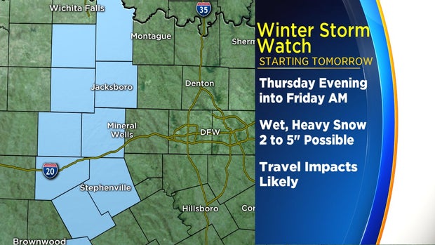
Even though temperatures will be just above freezing, the bursts of this type of snow can make some roads slushy and thus we could see some travel impacts. Bridges, overpasses and side streets will be most affected.
In the immediate Metroplex and the rest of the I-35 corridor will see a rain/snow mix overnight Thursday night into Friday morning. Amounts of any snow will be lighter compared to our western areas. We could see some of those big, wet snowflakes accumulate on grassy surfaces in the DFW area, but travel problems are expected to be fewer. Temperatures will be safely above freezing, but we can't rule out an isolated slick spot or two in the Metro Friday morning. Keep checking in to see if the snow forecast changes.

If you live east of DFW, it'll be all rain from Thursday night into Friday.
Rain or a rain/snow mix will end during the morning Friday, and it'll just be cold and windy during the day.
The Texas Department of Transportation began pre-treating roads and bridges with brine through the Metroplex on Wednesday in anticipation for the wintry forecast.