Wind Takes Out the Hot, Keeps the Fire
WIND IS A PROBLEM TODAY
The effects of Tropical Storm Lee (as of 4am finally on shore near Lafayette, LA and moving slowly up south central Louisiana and keeping to its script of not being very predictable) has muddled the drama of a powerful cold front coming through the metroplex now. The storm is about 330 miles to our SW but turned our winds to the NE yesterday and to the north overnight. This is a powerful front none the less, it is going to wipe out our heat wave, usher in 6 days of a north wind and keep us very, very dry. Its most dangerous effect will be the wind it is producing.
A RED FLAG WARNING is in effect until 8pm tonight from the metro area to the east and southeast.
A WIND ADVISORY is in effect today, we are getting winds 20-30 right now with 30-35 gusts reported at just about every hourly site. Since we are currently in the sharpest, most severe drought on record you can imagine the threat this wind has on fire conditions. There is also an advisory out for area lakes, white tops are reported at most of them keeping the boaters off the waters.
A FIRE WEATHER WATCH is in effect for all of north Texas tomorrow as the dry air arrives. Labor Day will be just as windy but with a dew points in the 30's (extremely dry air).
HEAT WAVE ENDS, DROUGHT DOES NOT
Yesterday it hit 100 degrees for what could be the last time this year. It will get back into the upper 90's in around the 12th and 13th so it's possible we could do it again given the dry soil. Over the last nine years we've only logged about 6 (six) days that reached at least 100 degrees, the odds are in our favor we have finally seen th last of it. Yesterday made it the 68th time this year we've suffered a 100 degree day. Ironically but appropriately, this falls one day short of the monster heat wave of 1980 which remains the benchmark for intense heat for north Texas. If you remember we fell TWO days short of the all-time record streak of 100 degree days (40 this year, 42 in 1980). We did make up for this shortfall with this year being the ONLY year with TWO top-ten streaks on that list. We just ended a 20 days run as of yesterday (tied for 6th on the list). The enduring legacy of this heat wave will be the brutal hot August and record high minimum temperatures (we shattered all the marks for 80 degree overnight lows, lows at 85 or above, all-time warmest mornings, etc). While this juiced up the AVERAGE temperature this summer to all-time status what it really means is that it's time to move the official temperature site again. The urban heat island effect is polluting the historical comparisons.
It's going to take two full days of a powerful north wind but its in the process of blowing the heat right out of our stretch of Texas. No only will it NOT hit 100 degrees, after today it won't even hit 90 degrees for the next week. Highs will stay in the low 80's tomorrow, the coolest day we've had since last Spring and stay in the 80's all work week into Saturday. We could still be talking temperature records. Tuesday morning it'll bottom out in the upper 50's. The all time record low for that date is 55 degrees set back in 1974. Yes, from record highs one week to record lows the next, you gotta' love Texas weather. How fast and dramatic the temperature change? Just two days ago, Friday's morning the low was 82 degrees. That'll be the high on Monday afternoon.
With the winds already turned to the north BEFORE the cold front arrived we are not getting the clash of air masses like we normally would when a cold front of this vigor hits us. Not to sound too dusty but there is no hot, moist gulf air in place for this front to make rain with. This translates to a poor 10% rain chance for today (being very generous with that by the way, a shower in your back yard today has about the same chance of a coyote stumbling across the jogging path of our Governor). The drought news just gets worse; there is practically no chance of rain starting tomorrow running to Saturday. No rain for the weary, no hope from the tropics this time around. In fact if anything, the tropics KEPT the rain away this time around.
TROPICAL STORM LEE: MASSIVE FLOODING AHEAD
Areas from the western coast of Louisiana to Panama City, FL have already logged 6-10 inches of rain. The problem is that is going to take a full day just to cross over the Bayou state and get into southern Mississippi. The forecast is calling for 12"-15" of MORE rain in these areas as well as inland in LA and the MS Delta area. Mobile Bay over to Panama City will be some of the worse hit areas with coastal flooding. You can imagine what this has done to the local economy that usually racks it in during the Labor Day weekend. Buckets of rain instead of buckets of gold.
This storm is going to have a long legacy I fear. As it slowly climbs over Alabama and into the southern Appalachia mountains flash flooding will be a huge threat over the next four to five days. It is far from over. It really has just began.
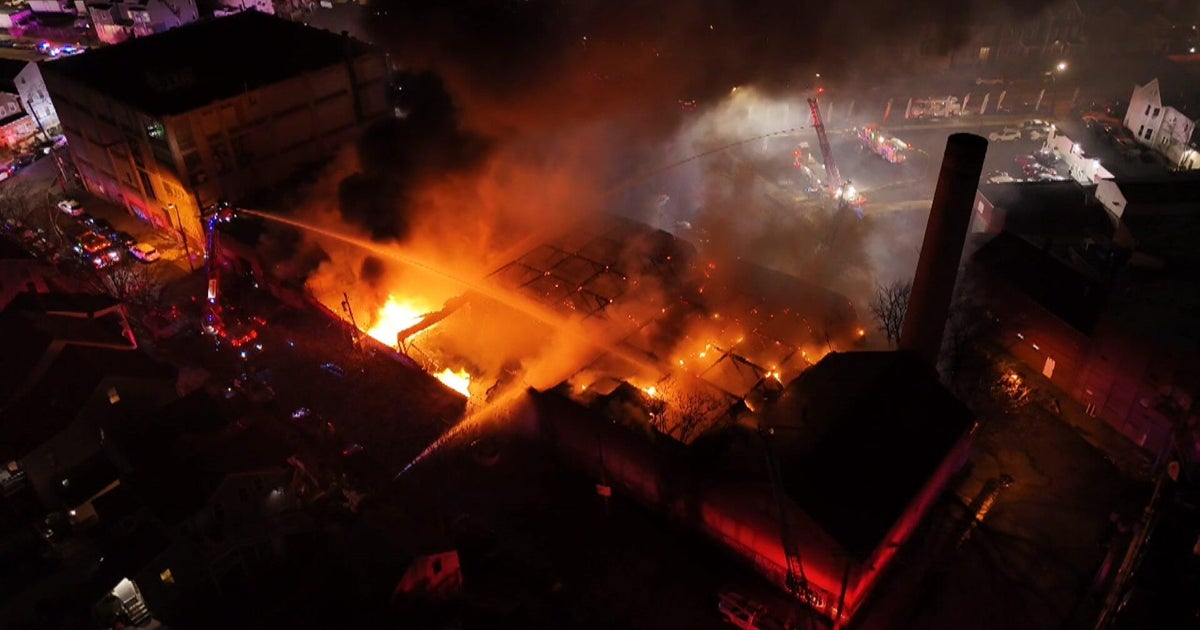
Prepare yourself for tomorrow morning when you go outside and it is in the low 60's. We haven't had a morning like that since May, it'll seem that you have changed latitudes. We might have forgotten that blazing hot is not the official forecast of Texas. Yes it'll be shockingly cooler unless of course you are in the path of a wildfire. Then the temperatures hits about 800 degrees and your house burns down in about 12 minutes. Please, please, please my fellow Texans watch with the smoking, the grill and spontaneous combustion of cleaning solvents. You shouldn't be smoking but if you do, don't flick those butts anywhere but into a water can.
So in summary:
HIGH WINDS NEXT COUPLE OF DAYS: HIGH FIRE DANGER
FROM RECORD HIGHS TO RECORD LOWS: WHOLE NEW FEEL TO THE AIR
STAYING DRY AS A BONE: RECORD DROUGHT GOES ON