Temperatures Forecast To Ease By Only A Bit
The upper level ridge of high pressure that has encouraged near record high temperatures over the past few days will begin to break down through the weekend. This will mean temperatures will not be quite as high as they have been…but at the surface, south winds will continue to keep things on the warm side. The storm track will continue to stay to the north of our area, keeping any cold fronts from penetrating North Texas in the next 7 to 10 days.
Our upper level winds will shift out of the southwest during the weekend and next week. This will bring tiny, discrete disturbances our way, which will trigger hit or miss thunderstorms beginning Monday and going through Wednesday. Without any fronts or boundaries to focus upon, rain will be hard to come by for the most part. This southwest upper level wind also tends to strengthen the famous cap over our area too. The cap acts as a lid to prevent clouds from building up tall enough for storms to form. This will also tend to limit our rain coverage for early next week.
FORECAST
Tonight…Mostly cloudy & breezy. Low 69° South wind 10-20 mph.
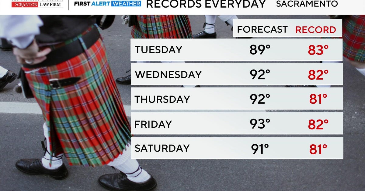
Tomorrow…Mostly sunny, windy, humid and very warm again. High 89° (Record high is 92°) South wind 20-30 mph
Saturday…Partly cloudy, breezy and warm. High 86°
Sunday…Partly cloudy, breezy and warm. High 84°
Monday-Wednesday…Partly to mostly cloudy, breezy, humid and warm. Isolated shower or storm possible each day..chance of rain 20%. Lows near 70°, Highs 84-88°