Temperatures In The 80s Before Arctic Front Brings Wintry Precipitation To North Texas
NORTH TEXAS (CBSDFW.COM) — Here's hoping that everyone enjoyed the beautiful weather over the weekend and plan to do the same today because big changes are on the way.
North Texas has an active week ahead, with another arctic front moving in.
Monday will be partly sunny, breezy and warm with highs in the lower 80s. There is a chance for spotty showers, mainly east of Interstate-35, during the day with increasing rain and storm chances overnight.
The overnight hours also bring a slight risk for a few severe storm, especially in areas to the northwest and along the Red River. There is a slight risk for large hail and damaging winds in these areas and the possibility of an isolated tornado can't be completely ruled out.
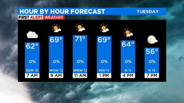
Showers clear out mid-morning on Tuesday and we have another mild day, with highs in the lower 70s. As the day progresses the arctic front arrives, causing temperatures to fall during the afternoon and bringing strong northerly winds. Grab a jacket before you leave because it will feel colder when you head home than when you left out in the morning.
The bad news -- Wednesday and Thursday also bring the potential for wintry precipitation. This means icing impacts are possible.
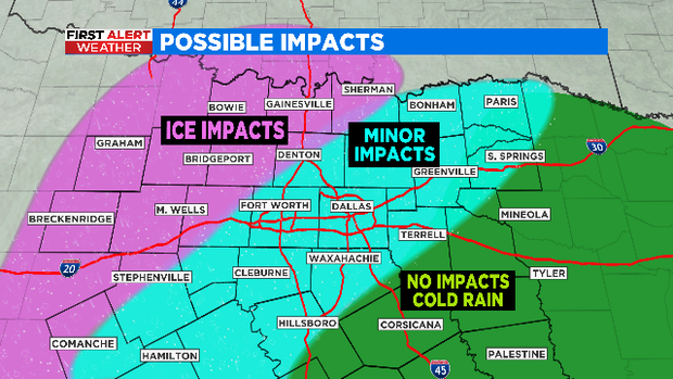
The Metroplex will wake up to temperatures near freezing Wednesday morning and it will stay cold -- in the 30s -- through the day. As it stands, models are trending colder so it may even end up a bit chillier. DFW is right in the transition area of a cold rain event, to a freezing rain/sleet event with some icing impacts. A few degrees up or down will impact the type of precipitation we see and potential icing.
Right now, it looks like areas to the southeast will get a cold rain with no impacts. Northwest areas will see freezing rain/sleet and have icing on bridges and overpasses and potentially some surface roads. The heart of the Metroplex is right in the middle and currently looking at minor impacts with icing on mainly elevated surfaces -- including bridges and overpasses.
The good news -- another round of sleet/freezing rain/rain is possible Thursday morning but temperatures warm to near 40° by afternoon. This is not the same setup as the storm we had earlier this month. Right now, precipitation amounts will be less and it won't be as cold for as long. Anything that is wet Thursday night will freeze overnight as temperatures fall into the 20s, leading to icy areas Friday morning.