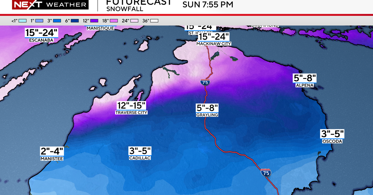
Cooler Weather With Rain & Storms
We had a few severe storms over Young, Jack, Stephens and Palo Pinto county last night. Reports of 60mph winds and half-dollar size hail were reported in these counties. They never reached into the metro area but storms did continue late into the night south of DFW. We have more rain/storms in the forecast for the next several days.
MONDAY:
Morning rain, cloudy skies, temperatures in the upper 60's and muggy. A cold front is heading towards us in the overnight hours, it should arrive here by early morning around 3-5am. A brisk south wind is all we've known so far this May; this finally changes by tomorrow morning as it turns to the north. We'll likely see a some clearing by afternoon before another system moves over north Texas by evening. Highs will stay in the low 80's. We'll enjoy a second chance of rain and storms tomorrow night. There is a slight risk of strong storms by evening.
TUESDAY:
This is another good chance of rain; about 40% coverage. It'll be cloudy all day with a northeast wind, I expect highs will stay in the mid-70's for most of us. Finally, a day of below normal highs! We've had a run of warm temperatures that stretches back two weeks! The early summer weather is going to take a break. Not expecting severe weather on Tuesday.
WEDNESDAY:
Should be dry with highs again staying in the upper 70's teamed up with a northeast wind. Morning lows will slip down into the 50's, the first time since April 24th.
THURSDAY/FRIDAY
We'll have enough sunshine to get us into the low 80's but storms could be coming in later that night. The better chance of rain shows up on Friday, another 40% chance. This will the third time in five days we'll enjoy decent rain chances. Highs should also stay in the 70's. Right expecting a dry weekend.