No relief from the heat in North Texas anytime soon
NORTH TEXAS (CBSDFW.COM) - I hope everyone had a fantastic Sunday! DFW hit 94 today, just a degree shy of tying the afternoon high temperature record of 95. Don't worry, we have several more chances for record heat through the upcoming week!
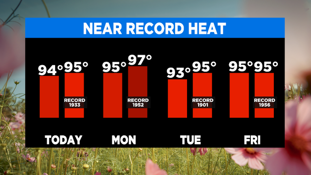
Monday starts with some cloud cover and temperatures in the mid 70s. Highs are once again in the mid 90s, with heat index values near 100. It is basically a rinse-and-repeat of today's weather, so I hope you enjoyed it!
An isolated dry line storm is also possible again Monday and Tuesday. Any storm first has to overcome the cap, but if they can manage it, they will likely become severe with a lot instability to work with due to the heat.
Large hail and damaging winds are the main threats. The rain chance east of I-35 is pretty much nil for the next week with a ridge of high pressure parked over us.
Tuesday, a disturbance will lift out of Mexico, giving a slightly higher chance for a storm to develop that afternoon or evening along the dryline.
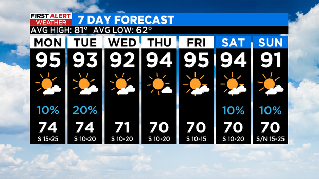
Southerly winds also remain gusty this week. A cold front tries to push in next weekend. Don't get too excited, it is still several days out.
Enjoy the rest of your weekend!