Is Winter Weather On The Way To North Texas Again?
NORTH TEXAS (CBSDFW.COM) - He's baaaaaack! Old Man Winter is threatening to visit North Texas again next week.
Now I know how the family in poltergeist felt.
February, as we all know by now, is the coldest and most wintry month in Texas. Not only were DFW's all-time coldest and second all-time coldest temperatures recorded near Valentine's Day, February 11 also holds the record for the biggest snowfall at 11.2 inches back in 2010.
And last time I checked the calendar, it's still February (my grandmother's 83rd birthday today, too! Happy birthday, Granny!). That means we're still under threat from wintry mischief from the north.
OKAY, BLAKE, YOU DONE DID GOOD WITH THE LAST EVENT, SO LAY IT ON ME. HOW BAD?
Well it's very early on, so the short answer is, "I don't know." We're still a full week out. When we're seven days out, we're just watching the trends and not the specifics because they will change a baker's dozen times by then.
What the trends are showing is an airmass that's getting colder and colder. Just like last time, they're picking up the event - but the severity or how cold it may be remains to be seen. However, things are trending towards a colder, more wintry outcome. However, easy come, easy go. Let's see how this plays out.
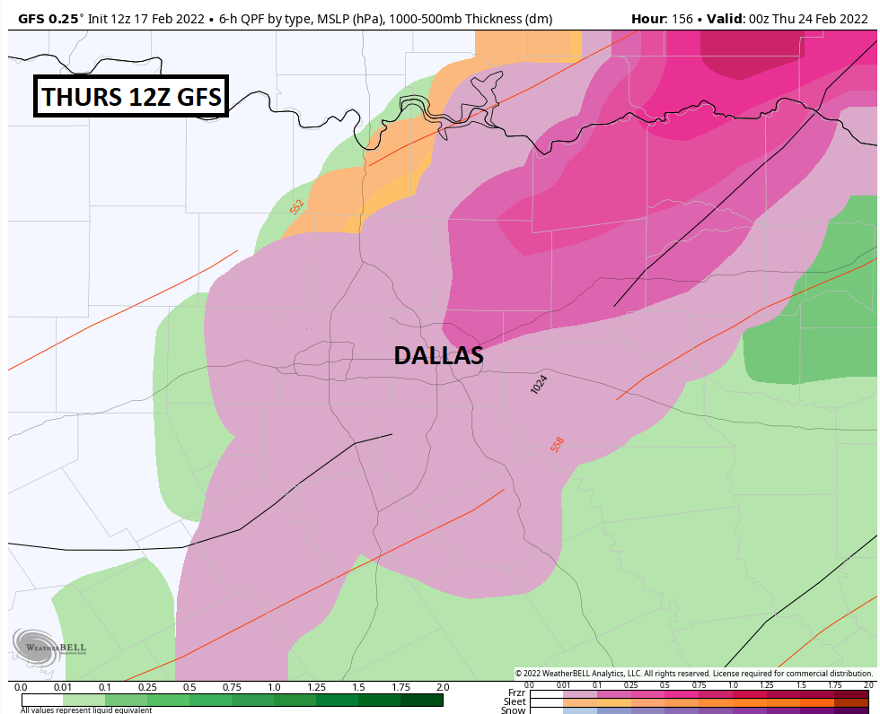
Currently, all of the "big three" computer models are showing wintry weather including sleet and snow. That includes the European model, the Canadian model, and the GFS. The European model is by far the most aggressive with the ice while the GFS is only so-so.
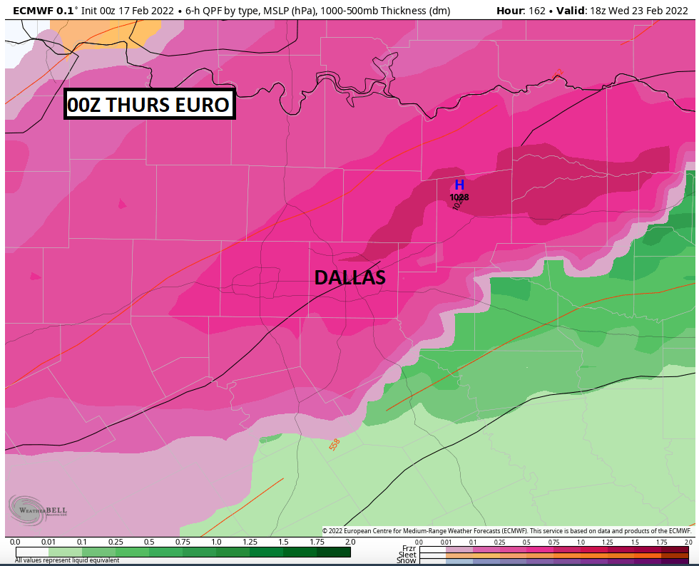
The Canadian model had all rain with only areas north of the state line maybe getting a sleet pellet or two, but as of this afternoon shows freezing rain, sleet, and snow across DFW.
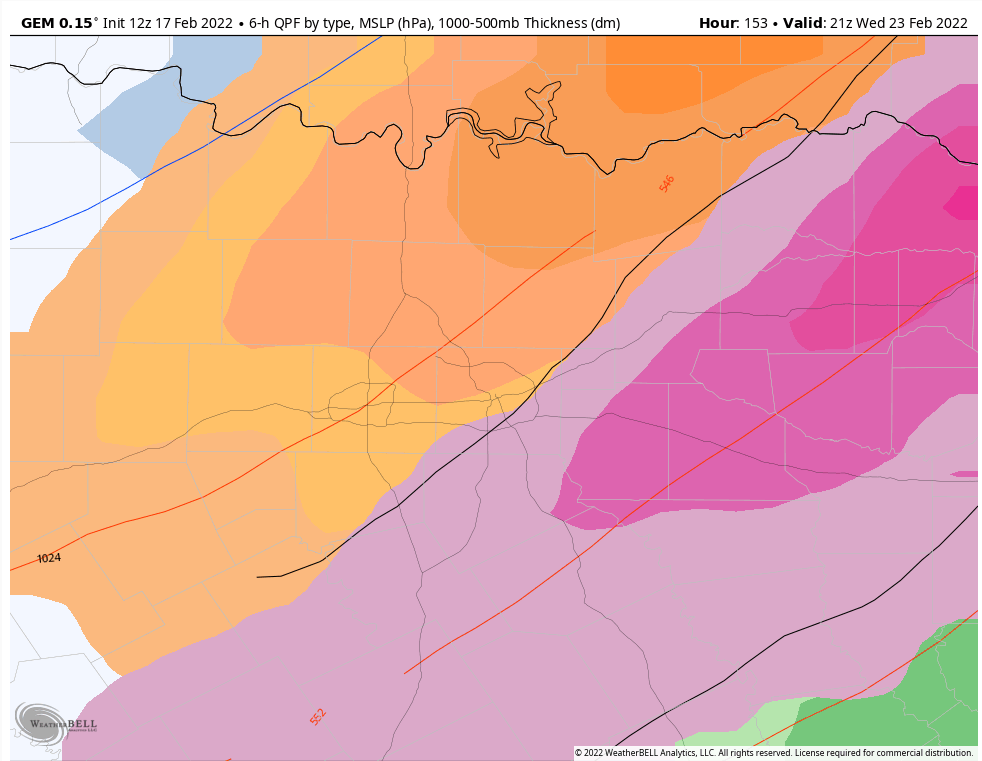
I can tell you that I am MUCH more inclined to lean on the GFS for these events than I am the other models.
Yes, the Euro is a great model and is often the gold standard in modeling. However, undoubtedly, that model has struggled BIG TIME with winter events. It completely missed last February's event until it was basically already occurring. It did a poor job with the winter storm we had a few weeks ago, too.
On the contrary, the GFS nailed last February's event over a week out, as it did the winter storm a few weeks ago. So right now, the GFS has my attention and it does show some wintry weather for Dallas-Fort Worth by next Thursday.
COULD THIS BE A REPEAT OF THE LAST WINTER STORM A FEW WEEKS AGO?
That remains to be seen. By the time this unfolds, it'll be towards the end of February (24th) and the sun angle is starting to get high. The arctic airmasses are modified more and more, especially with the lack of snowpack to our north.
With no snow pack, the cold isn't insolated on its trip south and moderates much quicker than it otherwise would. It depends on how cold the temperatures are but as I see it right now, it doesn't look as bad. However, it doesn't have to be "bad" to cause widespread travel impacts. Just a light glazing of ice can wreak havoc on the roadways.
WHAT SHOULD I DO?
Absolutely nothing. This could all vanish faster than a plate of cookies in my kitchen. Mmm, cookies! Anyway, just keep checking back to CBS 11 at least once a day. We'll know much more by Sunday and Monday.