Great Temperatures! But Still Need Rain.
FIRE DANGER STILL HIGH – RED FLAG WARNING UNTIL 9PM
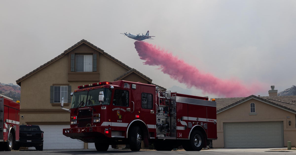
Despite the beautiful temperatures that have nestled into North Texas today, the wildfire danger remains quite high. The combination of strong north winds gusting over 25 mph, low relative humidity between 10-20%, and extreme drought is leading to quickly spreading, large and dangerous fires. All North Texas counties are under burn bans...no outdoor burning is allowed.
The wind will diminish after 9p and throughout the overnight hours to less than 10 mph. And tomorrow will not be nearly as windy as today has been. But until we get a good soaking rain, the risk of a wildfire getting out of control is still higher than normal. North Texas is average only 1 to 5% normal soil moisture content for this time of year.
DO WE DARE CALL TONIGHT CHILLY?
After weeks of battling the intense heat of the hottest summer on record, our weary souls have rejoiced in the mild crispness of today's air mass. The weather pattern shift is here to stay for the rest of the week…allow cooler air to our north to funnel in on a north wind. In fact, tonight with lighter winds & clear skies…look for temperatures to drop to levels we haven't seen in 3 ½ months! On May 17th we dropped to 54° at DFW. Tonight we're forecasting lows near 58°. And after being battered with numerous record high temperatures over the summer, we will actually be threatening a record low for tomorrow morning: 55° set in 1974.
COOL NIGHTS, WARM DAYS
As mentioned, our weather pattern will keep us with a string of today's similar weather for the rest of the week. The bad news is that we don't have any rain in our forecast. But the temperatures will be below normal all week. Cool in the morning and warming up during the afternoon…we will get progressively warmer as we move through the weekend.
Tonight…Clear and COOL!! Low near 58° North wind 5-10 mph
Tuesday…Sunny and mild. High near 85° Northeast wind 5-15 mph
Wed-Fri…Fair to partly cloudy. Lows near 60° Highs 86-89°
ANY HOPE FOR RAIN IN THE TROPICS?
As "Lee" moves away from us into the eastern part of the country, we are still watching Hurricane Katia in the Atlantic. As of this writing, it is a major hurricane, category 3, with maximum sustained winds near 115mph. It is still nearly 1000 miles away from the outer banks of North Carolina. It is forecast to move northwest in between the east coast of the U.S. and Bermuda by late week. All of the computer models then shift it back to the northeast into the open waters of the northern Atlantic.
There is another tropical disturbance (INVEST 95L) way out there in the eastern Atlantic. This one has formed a bit south of where Katia did..this could suggest it has more of a chance of moving closer in toward the Caribbean and possibly threaten Florida, but this wouldn't happen until late next week, if at all.