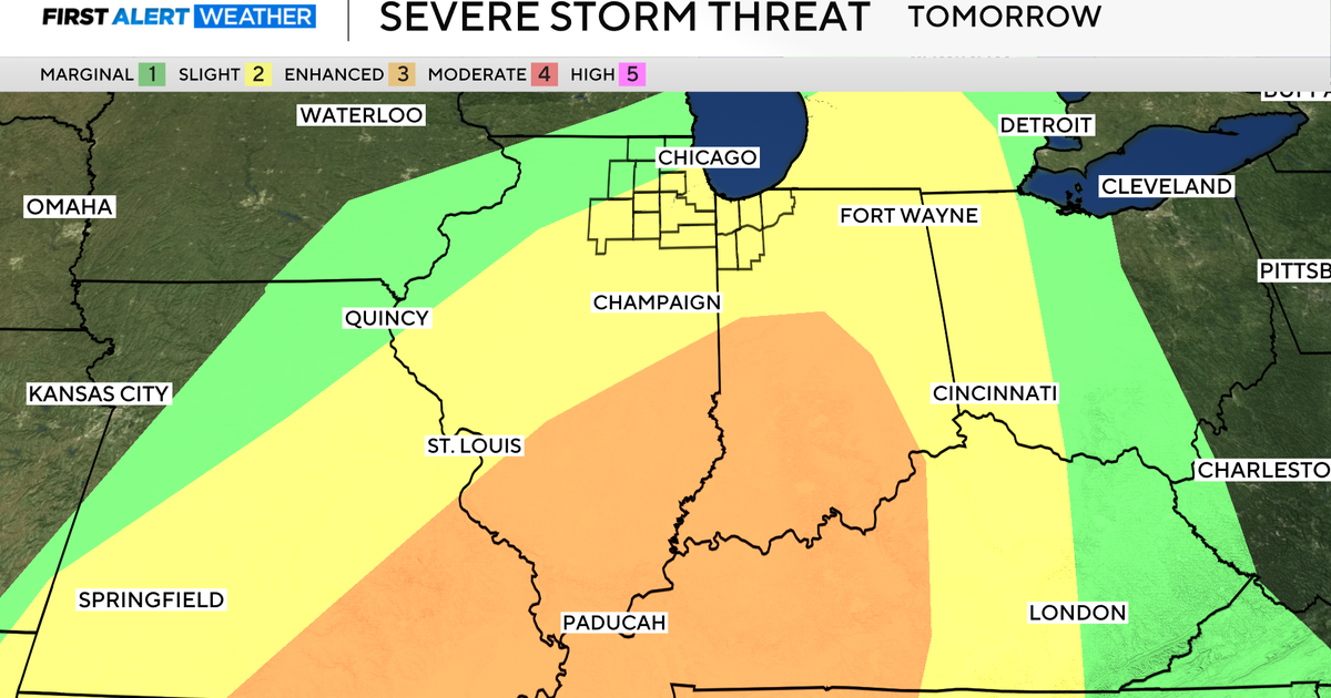
Forecast Discussion for Wednesday, April 20th
COOL AND CLOUDY THIS AFTERNOON…
A front has stalled out in our southern counties this afternoon. Temperatures in Dallas and Fort Worth where in the mid 60s but in Waco it is 84 degrees and in Palestine it is 88. Along and south of this front storms will develop over the next several hours. Some of these will severe with large hail the main threat.
Also to our northeast from Clarksville to Texarkana into Southeast Oklahoma and Arkansas another cluster of storms has already developed. So for the afternoon there are two areas of North Texas that could see storms. Both areas are far away from Dallas and Fort Worth.
There are two counties in our DMA that are under a Severe Thunderstorm Watch. One is Red River County which is in far northeast Texas. The other is Hamilton which is in far southwestern sections of North Texas. Above is a map showing the Watches. One to our northeast the other to our southwest in the Hill Country.
OVERNIGHT…
The front to the south will slowly lift northward overnight. That combined with a low level jet transporting moisture from the Gulf of Mexico over the cooler air at the surface will mean scattered showers and thunderstorms tonight. The favored area for rain overnight will be for areas south and east of Dallas. But a few showers and storms could be possible in the metroplex tonight. There is slight chance some of these could be severe with hail being the main threat overnight.
TOMORROW…
That front will try to make it to the Red River tomorrow so we will get back into the warm moist air again by the afternoon. Temperatures will climb into the upper 70s and low 80s tomorrow with some mid 80s just to our south. Scattered showers and thunderstorms will once again be possible tomorrow.
DRYLINE ACTIVITY FRIDAY THRU THE WEEKEND…
The dryline will set up each afternoon Friday, Saturday and Sunday just to the west of Fort Worth. Storms are possible each day along that dryline. These storms will have a high likelihood of being severe each afternoon. The good news is that there is at least the chance of getting one of those storms over the PK fire Friday, Saturday or Sunday. These storms that develop along the dryline will move primarily to the north and east. This would keep most of the storms just north and west of Dallas/Fort Worth. But it really all depends on the location of the dryline each day. One or all of those days, storms that roll off the dryline could creep into the metroplex by evening.
NEXT WEEK…
We might see a stronger upper level disturbance push a cold front thru either Monday or Tuesday of next week. The timing varies between the models, this would once again bring good storm chances either day. But behind the front we would dry out and end storm chances for a little while.