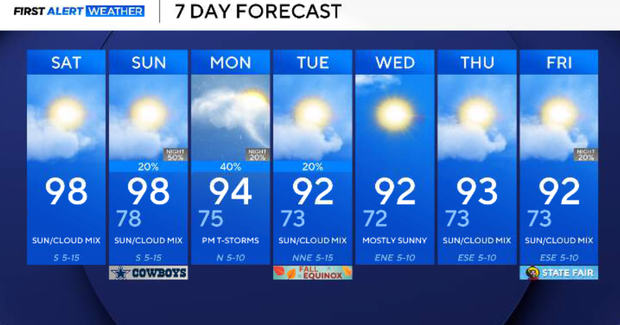
North Texas temps in the 90s for late September, elevated fire threat for Saturday

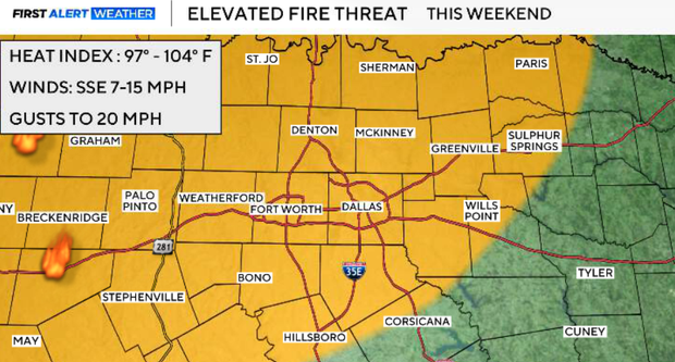
We have an elevated grass fire danger today, as the combination of very dry vegetation, low humidity, and increasing southerly winds creates a wildfire threat across much of North Texas. South winds will increase to around 10–15 mph, with some gusts to 20 mph this afternoon.
The strong upper-level ridge that has dominated our weather finally begins to weaken and shift southeast on Sunday as a shortwave moves across the Central Plains. That opens the door for a weak cold front to approach North Texas, bringing our best opportunity for showers and thunderstorms in quite some time. Storm coverage Sunday evening is currently expected to be around 30–50%, with the initial development favoring the Big Country, Texoma, and areas north and west of DFW before storms move southward. A few storms could become strong, with hail and damaging wind gusts possible in isolated cases.
Expect plenty of sunshine and another hot afternoon for Saturday. High temperatures reach the upper 90s to around 100°, roughly 10° above normal for this time of the month. DFW should top out around 98–99°. The daily record is 102°, so we'll remain below record territory. The bigger concern today is the elevated grass-fire threat. Southerly winds increase to around 10–15 mph, while afternoon humidity falls considerably. With the worsening drought and extremely dry vegetation, any fire that develops could spread quickly. The forecast remains completely rain-free today.
Mostly clear and warm conditions continue this evening. Overnight lows should fall into the low and mid-70s across many surrounding communities, with upper 70s closer to the Metroplex.
Most of Sunday morning should remain dry. A few showers could develop as early as the morning across Northwest Texas, but the more significant thunderstorm opportunity holds off until later in the day. Sunday will also become more humid as moisture increases ahead of the approaching front.
The upper ridge weakens and shifts away as a weak front approaches the Red River on Sunday afternoon. Storms should initially develop from roughly the Big Country northeastward into Texoma during peak afternoon heating, then tend to move southward along developing outflow boundaries. That means storms could begin reaching parts of North Texas during the evening. Overall coverage is currently expected to be around 30–50%. The atmosphere will be unstable, with sufficient wind shear for some storms to organize into clusters or short lines.
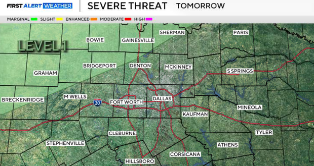
A few storms could become strong or marginally severe, capable of:
- Damaging wind gusts
- Hail
- Frequent lightning
- Brief heavy rainfall
The severe threat is not expected to be widespread, but a few stronger storms are certainly possible.
Storm intensity should gradually decrease after sunset on Sunday as instability diminishes. However, the nearby front and continued lift from the upper-level disturbance could keep isolated showers and thunderstorms going overnight into early Monday morning. Rainfall will remain uneven. This does not look like widespread drought-ending rain.
Monday's forecast becomes highly dependent on exactly where Sunday's front and thunderstorm outflow boundaries end up. Additional thunderstorms are expected to redevelop as daytime heating builds, with the most likely area currently near and south of I-20. Temperatures should be noticeably lower than this weekend, generally in the low to mid-90s.
On Tuesday, another upper-level disturbance will help reinforce the front and push it farther south through North Texas. The air behind it isn't dramatically cooler, but it should introduce lower humidity. Low rain chances continue at least on a limited basis as the boundary moves through. Tuesday also marks the first day of astronomical fall, and while it won't exactly feel like fall, temperatures should be considerably better than the triple-digit heat we've experienced this month.
The biggest difference during the middle and latter part of next week should be the absence of the extreme heat. Highs should settle much closer to seasonal averages, generally around the upper 80s to lower 90s, although some locations could remain slightly above normal. Lower dew points should also make conditions feel less humid. Rain opportunities decrease again later in the week, with predominantly warm and dry conditions returning.