Scattered rain, storm chances return to North Texas amid high heat and humidity

Thursday is off to a warm and muggy start, with temperatures in the upper 70s and low 80s. South winds remain breezy, and low clouds continue streaming north across the region. Humidity remains high, with dew points well into the 70s.
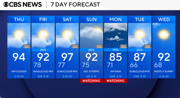
By the afternoon, it will be partly sunny, hot and humid. High temperatures will reach the low to mid-90s with heat index values ranging from 100° to 106°. A ridge of high pressure remains in control, keeping North Texas dry. South winds will gust between 20 and 30 mph at times.

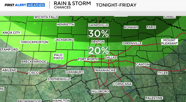
Clouds will gradually increase overnight as a cold front settles south toward the Red River. Most locations remain dry through midnight, but showers and thunderstorms are expected to develop near the Red River late tonight into the pre-dawn hours Friday.
Scattered showers and thunderstorms are expected mainly north of I-20 from roughly 3 a.m. Friday through midday. The stalled frontal boundary near the Red River will serve as the focus for storm development. A few storms may produce gusty downburst winds and frequent lightning, but the overall severe weather threat remains low.
Cloud cover and outflow boundaries may keep temperatures north of I-20 in the upper 80s, while areas farther south climb back into the low to mid-90s. Additional isolated storm development will be possible on Friday afternoon, depending on how morning storms evolve.
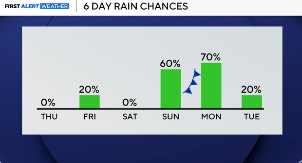
Saturday looks mostly dry but very hot. Weak ridging briefly builds across North Texas, allowing temperatures to climb into the mid- and upper-90s. Heat index values could range from 100° to 108°, and some locations may approach Heat Advisory criteria.
By Sunday, the pattern becomes more active again as a stronger upper-level disturbance approaches the Southern Plains and another front moves toward North Texas.
Looking ahead
Sunday and Monday currently appear to be the most active weather days of the extended forecast. A front approaching from the north, combined with increasing moisture and several upper-level disturbances, will bring the chance for widespread showers and thunderstorms back to North Texas.
Forecast confidence is increasing that some storms could become strong to severe on Sunday, especially along and north of I-20, where wind shear will be slightly more favorable for storm organization. Heavy rainfall will also be possible, and Monday may ultimately become the wettest day of the forecast depending on where lingering boundaries set up from Sunday's storms. Rain chances begin to decrease by Tuesday as drier air gradually works into the region.