Bottom Falls Out Of Thermometer As Rounds Of Winter Precipitation Head Toward North Texas
NORTH TEXAS (CBSDFW.COM) — North Texas is preparing for rounds of winter precipitation Wednesday night into Thursday morning, with a light icing threat for counties northwest of the Metroplex.
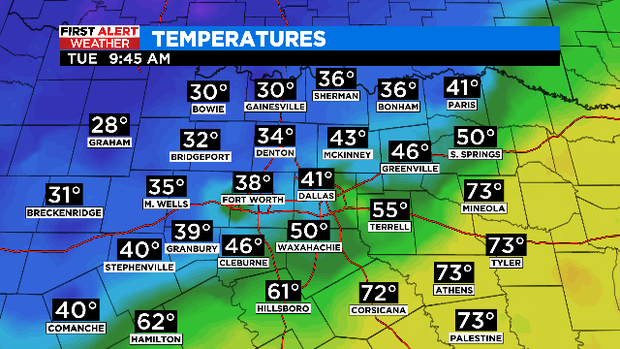
After early Tuesday morning temperatures in the 60s, an arctic cold has moved in and dropped temperatures into the 30s, where they will remain most of the day.
Overnight storms have given way to drier conditions with occasional breaks in the clouds. Along with the falling temperatures, northerly winds are breezy and adding to the chill across North Texas.
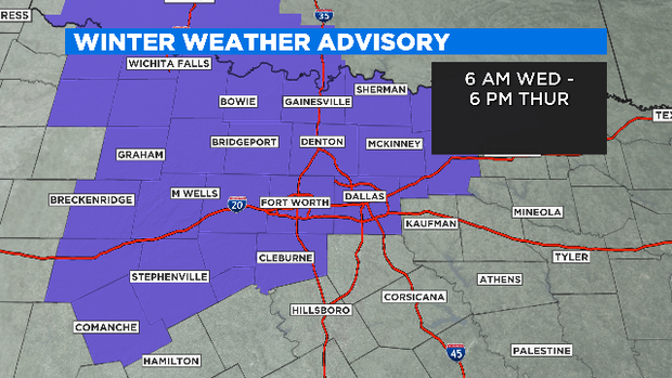
A Winter Weather Advisory goes into effect at 6:00 a.m. as we start monitoring for rain, freezing rain and sleet. Light, spotty rain will develop before sunrise. Temperatures at or below freezing are expected, so freezing drizzle becomes a concern early -- especially well to the west of Interstate-35.
Temperatures will hardly rise out of the lower 30s Wednesday afternoon. Things get even more frigid in the evening hours, with lows dipping down into the 20s. The possibility of light icing on elevated surfaces becomes concern as the day wears on.
This forecast remains very tricky as the slightest variation in temperature will make all the difference. Bottom line: it will be wet and cold with some light ice accumulation across North Texas Wednesday through Thursday.
This weather event doesn't have quite the moisture content that the early February event had.
Stay tuned! The First Alert Weather Team will keep you posted of any changes along the way.