Arctic Air Moves Into North Texas Tonight, Brings Chance For Freezing Rain & Light Snow
NORTH TEXAS (CBSDFW.COM) — Tuesday morning there is some freezing drizzle in locations across North Texas, but only enough to possibly impact elevated surfaces and cover some windshields... but a bigger change is coming.
Moisture is expected to buildup overnight, bringing the chance for light, scattered showers on Wednesday.
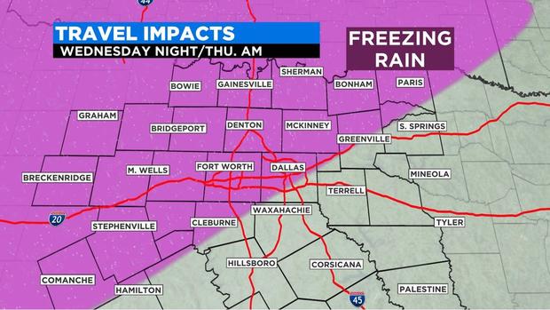
There is the possibility icy conditions could cause problems on bridges and overpasses during the overnight hours on Wednesday into Thursday. As it stands, the best chance for freezing rain will be in areas northwest of the Metroplex.
The Texas Department of Transportation (TxDOT) has already started prepping roads for potential icy weather.
Crews are treating highways with a brine mixture that lowers the freezing point of water and prevents roadways from freezing over. Warning signs will be flashing along roadways for the next couple of days -- a warning to drivers to give crews the space they need to work.
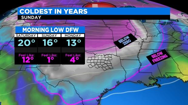
Even colder air moves in on Friday, making for a frigid weekend. If the forecast holds out, high temperatures on Sunday will be in the 20s and wind chills in the single digits -- making it the coldest day at DFW since 2014.
Right now it looks like the Arctic air plunge peaks on Monday.
MORE FROM CBSDFW


