Satellite images show Turkey-Syria quakes "similar to the 1906 earthquake that destroyed San Francisco," NASA says
Satellite images from the NASA Earth Observatory show the scale of destruction in Turkey and Syria after massive earthquakes left over 20,000 people dead and millions displaced.
The magnitude 7.8 and 7.5 quakes struck southern Turkey and western Syria on Feb. 6. Eric Fielding, a geophysicist at NASA's Jet Propulsion Laboratory, said that the "very large and powerful earthquakes" did damage similar to the 1906 earthquake that "destroyed San Francisco."
The earthquakes "ruptured all the way up to the surface over a long series of fault segments," Fielding said.
Thousands of buildings are estimated to have collapsed. Rescues have been underway, but complicated by conditions on the ground including freezing weather and infrastructure issues. So far, the death toll stands at over 20,000 people, with tens of thousands more injured and five million displaced from their homes.
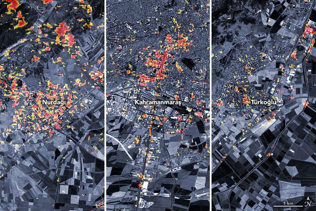
The satellite imagery shared by the NASA Earth Observatory shows the damage to three Turkish cities. Dark red pixels indicate areas "likely to have severe damage" to buildings, homes and infrastructure, while "orange and yellow areas are moderately or partially damaged."
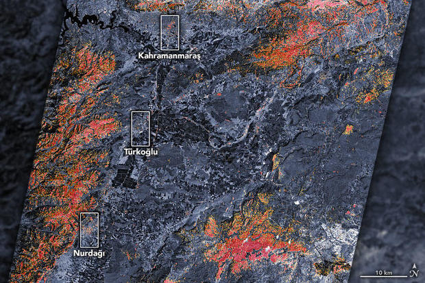
According to the observatory, each pixel represents a space of about 30 meters, approximately the size of a baseball infield. The maps show large swaths of red pixels, bordered by orange and yellow areas; when the maps are zoomed in on, viewers can see smaller pockets of damage throughout the country. The data will be continuously updated.
The maps were made by using a satellite's synthetic aperture radar. The radar is a sensor that sends microwave pulses towards Earth's surface, then listens for reflections of those waves to map the landscape. The landscape map includes buildings. Scientists at the observatory compared data from Feb. 8, two days after the quakes, to data collected in April 2021 and April 2022 and tracked the changes to identify damaged areas.
Fielding cautioned that "seasonal variations" may cause some inaccuracies: "Some of the areas marked as damaged in vegetated areas may not have been damaged, and some areas showing no damage in vegetated areas may be damaged," he said.
The map is being used by the disasters program team of NASA's Earth Science Applied Sciences Program to work with the U.S. State Department, the California Seismic Safety Commission, Miyamoto Global Disaster Relief and the World Bank. The team is also coordinating with the U.S. Agency for International Development to "assess the needs of stakeholders in the region and provide scientific expertise to support risk assessment and recovery efforts," NASA said in a news release.
"We're monitoring this event closely," said Shanna McClain, the manager of the program. "In addition to mapping damage to the extent possible from satellites, we're using satellites to track increased landslide risks, power outages, and weather that could pose challenges to response efforts."


