Caldor Fire Update: Wildfire Jumps Hwy 50, Grows to Over 98,000 Acres
EL DORADO COUNTY (CBS13/CBS SF) – Flames from the Caldor Fire jumped the still shut down Highway 50 Saturday evening as the massive blaze in El Dorado County continued to grow.
The fire has now scorched 98,149 acres or 153 square miles, destroying around 328 structures. It is still 0% contained.
According to a CBS13 report, the spot fire across from the highway seemed to pick up by Saturday night.
"This was one of the control points – so it does raise some concern," said Cal Fire Captain Robert Foxworthy.
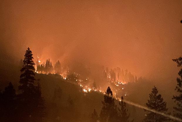
The glowing orange flames on the hillside could be seen from the highway below. The Caldor Fire also tore through trees and rose over ridges near the Gray Rock Campground off of Silver Fork Road throughout Saturday afternoon.
"That fire is breathing today and it's getting moved along with that wind activity," said Captain Keith Wade, a public information officer working on the Caldor Fire.
Red flag conditions fanned the flames and created smoky, orange skies around a closed Highway 50, only miles away from the evacuated tiny town of Kyburz.
However, the Red Flag Warning in the area expired Saturday evening, and weather conditions including reduced winds and milder temperatures were favorable for the next few days.
The growing fire, started by unknown causes last Saturday, prompted the USDA Forest Service Pacific Southwest Region to temporarily close nine National Forests. Beginning Sunday, Aug. 21, these parks and the roads and trails inside them will be off limits to visitors until Sept. 6. Read the announcement for more information.
CALDOR FIRE: Incident Information, Evacuations, Maps
Officials said much of the burning areas of the Eldorado National Forest haven't seen fire in decades.
"The fuels are thick," said Wade. "They're prime to burn."
Crews strategically scattered around the area, including in Kyburz, prepared for what could come and what wind shifts may bring.
"They're in for a firefight," said Wade. "But they're doing the best they can."
Air quality on Saturday made air attack near impossible and made for a tough firefight amid rugged, steep terrain. Highway 50 remains closed from Sly Park Road to Meyers with thousands of homes still threatened.
EL DORADO COUNTY - EVACUATION ORDERS
- Grizzly Flat: The areas on Grizzly Flats Road east of Kendra Way into Grizzly Flats Proper. The areas of Diamond Railroad Grade, Old School House, Sweeney Road, Caldor Road, and steely Ridge.
- Grizzly Flats Road east of four corners in Somerset into Grizzly Flats Proper.
- The areas of Myers Lane, Varmet Ridge Road, Rodwell Canyon Road, Snowbird Lane, and Mehwald Lane.
- East of Sly Park Road between Highway 50 and Mormon Emigrant Trail to Ice House Road. This includes the communities of Pacific House and Fresh Pond.
- North of Highway 50, east of Forebay Road to Ice House Road.
- Intersection of Perry Creek and Hawk Haven, the East side of Fairplay Road from Perry Creek South to Cedarville Road.
- This includes Slug Gulch, Omo Ranch, and all roads off of Slug Gulch and Omo Ranch.
- All roads off of Omo Ranch from Cedarville Road to Hwy 88.
- The area between Highway 88 and Mormon Emigrant Trail
- South of Farnham Ridge Road and east of Bridgeport School Road south to the Amador County Line
- South of Highway 50 from Snows Road to Ice House Road.
- Between Highway 50 and Slab Creek from Snows Road to Ice House Road.
- South of Highway 50 from Ice House Road to Silver Fork Road. This includes the community of Kyburz.
- North of Highway 50 from Ice House Road to Silver Fork Road to include Ice House Reservoir, Union Valley Reservoir, and Loon Lake.
- Silver Fork Road in Kyburz east to Twin Bridges.
- North and south in a line extending from Twin Bridges to the Placer County line and south to the Amador County line.
EL DORADO COUNTY – ROAD CLOSURES
- Highway 50 will be closed in both directions from the Sly Park Road exit to Twin Bridges.
- Highway 50 will be open between Meyers and Twin Bridges for local residents only who reside between Meyers and Twin Bridges. These residents will be subject to providing identification and proof of residency. No traffic will be allowed west past Twin Bridges.
For more information on evacuation warnings, visit the Cal Fire website.


