First Alert Weather: Heavy rain, snow, flooding hit Northern California; thunderstorms still on deck
Light showers are continuing across the Sacramento region, with light to moderate showers moving west to east. Then on Tuesday night and continuing into Wednesday, a weaker storm blows in.
To view the hourly forecast or radar, click here.
Snow totals over the weekend
Boreal has received nearly three feet of new snow since Saturday morning, the National Weather Service says.
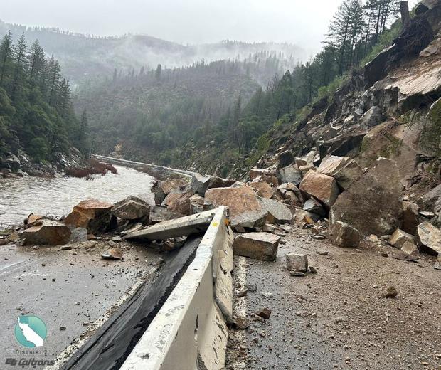
Highway 70 rockslide
Caltrans says Plumas County drivers should expect Highway 70 to be closed for an extended period of time from Jarbo Gap to Greenville Wye due to a big rockslide.
No estimated time of reopening is known at this point.
Weather forecast
Isolated thunderstorms are still in store for the region on Monday.
CBS13 Meteorologist Tracy Humphrey has the breakdown of what kind of weather is on deck:
Modesto Highway 99 problems
Southbound Highway 99 continues to be a problem spot for drivers Monday morning.
Along with the flooding just north of Tuolumne Road, which is significant enough to be blocking the middle and slow lanes, California Highway Patrol says they're also now dealing with a big rig crash at Kansas Avenue.
Officers are urging drivers to avoid southbound Highway 99.
Highway 99 flooding
Caltrans is warning drivers in the Modesto area that there is localized flooding going on along southbound Highway 99 near Tuolumne Road.
Drivers are being urged to use a different freeway for now.
Flood Advisory
The National Weather Service has issued a Flood Advisory for Stockton and parts of Modesto until noon on Monday.
Moderate to heavy rain is expected to persist through the morning, forecasts show.
Localized urban flooding is possible. People are being urged to drive with extra caution and slow down.
Jackknifed big rig on I-5
A big rig has jackknifed on southbound Interstate 5 in Sacramento as wet weather continues to impact traffic Monday morning.
The crash happened just after 4:30 a.m. near the J Street offramp.
Caltrans is warning that they may need to close I-5 for a short time to remove the wreck.
Drivers all across the region should leave themselves a little extra time to get to where they're going Monday.
I-80 chain controls
Chain controls went into effect on Interstate 80 in the Sierra late Sunday night.
Eastbound travelers are required to have chains on all vehicles except 4-wheel-drive vehicles with snow tires on all four wheels from Cisco to the Donner Lake Interchange.
Those same requirements apply to westbound travelers from the Donner Lake Interchange to Nyack.
As of 11 p.m., no chain requirements were in effect on Highway 50.
Radar pick up heavy rain
Heavy rain is starting to fill in between Yuba City and Stockton.
Rain Arrives
Rain has hit the valley and will continue through the night into early Monday morning. There will be rounds of heavy rain over the next several hours and winds could gust up to 35 mph across the valley.
The heaviest rain could happen around 9 or 10 p.m., the National Weather Service says.
Flood Watch
A Flood Watch will go into effect Sunday night through Monday night.
48 hour rain, snow totals
As a second storm is making its way to the valley and Sierra, the last 48 hours have brought rain and snow.
Here's the 48-hour snow report as of Sunday morning:
- Boreal: 16"
- Sugar Bowl: 13"
- Palisades Tahoe: 9"
- Northstar: 8"
- Dodge Ridge: 6"
- Sierra at Tahoe: 4"
Here's the 48-hour rain report as of Sunday morning:
- Auburn: 1.46"
- Sacramento: 1.03"
- Folsom: 1.02"
- Davis: 0.92"
- Modesto: 0.73"
- Stockton: 0.45"
Chain control update
On Interstate 80 in the Sierra Sunday afternoon, eastbound trucks must carry chains in order to continue past Applegate. For trucks heading west, chains are being screened five miles west of Reno.
Chain controls were lifted on I-80 over Donner Summit at about 10 a.m. Sunday.
As for Highway 50, there were no chain restrictions as of 2:45 p.m.
UC Berkeley snow lab
The UC Berkeley Central Sierra Snow Lab reported that it received nearly eight inches of snow in the last 24 hours, bringing the storm total to nearly 9 1/2 inches.
Sierra Avalanche forecast
The Sierra Avalanche Center said Saturday's storm did not meet expectations but that there was enough to make triggering avalanches more likely on Sunday.
Avalanches are possible where weak snow sits below the surface or in places where wind-blown snow has piled up.
Experts believe the next storm, moving in Sunday night, will create impacts and the avalanche danger could reach 'high.' They are concerned about large to very large avalanches over the next several days, leading to an Avalanche Watch being placed into effect.
Sunday's backcountry forecast:
- Below treeline: Considerable
- Near treeline: Considerable
- Above treeline: Considerable
Monday's backcountry forecast:
- Below treeline: High
- Near treeline: High
- Above treeline: High
Flooding in Placer County
The South Placer Fire District responded to a neighborhood in Granite Bay where firefighters had to divert water from entering homes.
Firefighters said no homes were damaged.
I-80 released
Eastbound I-80 has been released at Castle Peak after multiple crashes and spin-outs.
Highway 50 chains
Chains are required on Highway 50 from Twin Bridges to Meyers in the Sierra. This is required for all vehicles except 4-wheel-drive vehicles with snow tires on all four wheels.
I-80 held
Due to multiple crashes and spin-outs, the CHP Truckee said eastbound I-80 was being held at Castle Peak at about 7:45 p.m. There is no estimated time the eastbound side of the interstate will reopen.
Chain controls
Chain controls went into effect on westbound Interstate 80 from the Donner Lake Interchange to Rainbow. Eastbound travelers will run into chain controls from Kingvale to the Donner Lake Interchange, the CHP said.
The CHP added that trucks are at minimum restrictions.
Flooding
Around 3 p.m., CBS13 heard reports from Caltrans of roadway folding near Cal Expo at Highway 50 East and Howe Avenue off-ramp.
Caltrans is asking anyone who may be traveling in the mountains to delay their travel through the weekend due to the storms.
Thunderstorms
A thunderstorm developed over Rocklin, producing lightning, gusty winds and heavy rain around 3:30 p.m. About an hour later, thunderstorms developed near Turlock.
The heaviest rain was seen right up against the foothills where it is starting to change over into snow in the Sierra.


