Strong to severe storms possible in Pittsburgh on Saturday afternoon | First Alert Weather

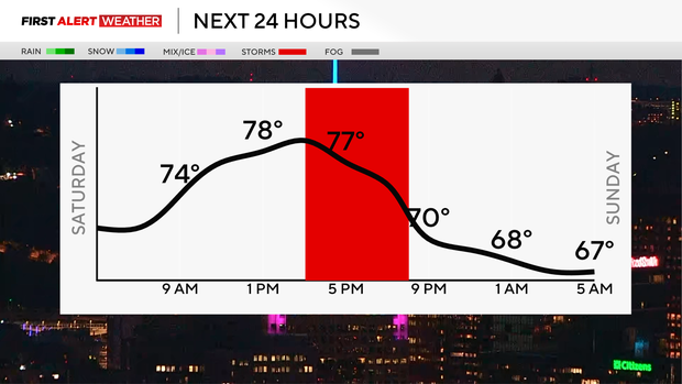
Today is a KDKA First Alert Weather Day with strong to severe storms expected after 2 p.m. Storms will move through Pittsburgh around 4- 6 p.m.
Damaging winds and hail are the biggest threat, but an isolated tornado can't be ruled out, meaning one or two warnings could happen for some areas. Our severe weather threat is a 'slight risk,' which is a 2 out of 5 on the Storm Prediction Center Outlook.
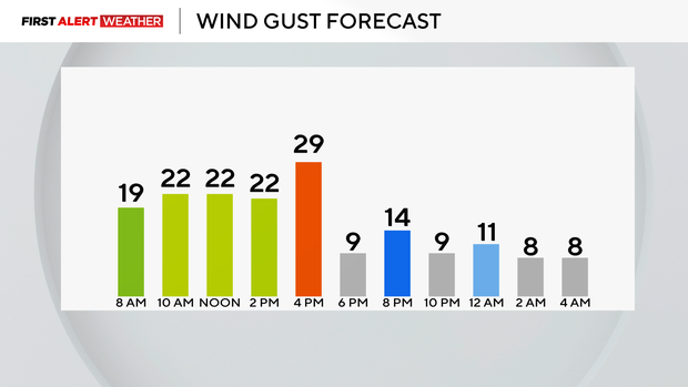
You will need to stay weather-aware today as this line moves in because heavy downpours are likely, which will put a damper on outdoor events, along with wind gusts of around 20- 30 mph ahead of the system.
Hourly Forecast:
- 9 a.m: 72° Cloudy
- Noon: 78° Cloudy
- 3 p.m.: 79° Mostly Cloudy
- 6 p.m.: 77° Strong Storms
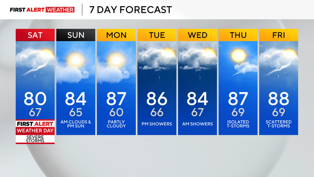
All of the ingredients are in place for severe weather, so have that backup plan in place. You will have dry time this morning and afternoon to enjoy, but it's warm and muggy with temperatures near 80 for our high.
After 9/10 pm tonight, they will move south of I-70, and then we have patchy fog possible overnight and then a quiet and dry Sunday with highs in the mid 80s.
Next week will be very humid and hot, with highs in the upper 80s and feels in the 90s for some. Make sure you find ways to stay cool and hydrated and take breaks in the AC.
Tuesday night and Wednesday morning will be our next chances for rain showers.