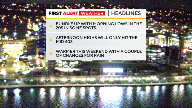
Wednesday will be the coldest day of the week before temperatures warm up
Any Alert Days Ahead? None at all.
Aware: We started off this week with temperatures running more than 9 degrees warmer than average for the month. That is now down to just +7.2 degrees.
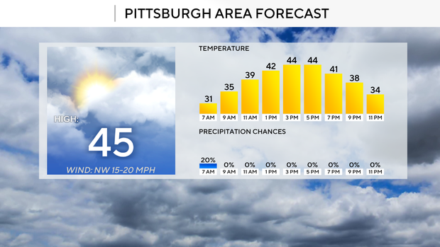
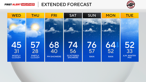
Grab the jacket as you head out on Wednesday with highs only expected to hit the mid-40s. Wednesday will be the coldest day of the week, and we will see a weather pattern that is more in line with 'spring' by the weekend. That includes plenty of rain, and highs soaring to the 70s on Saturday and Sunday.
850mb heights show a temperature of just -8°C Wednesday afternoon. 850mb temperatures are one of the best ways to measure the warmth, or coolness in this case, of air masses. Normally for us our 850mb temperatures hover near 0 degrees to -20 degrees in the winter. In spring they can fluctuate anywhere from -12 degrees to +12 degrees. Heading into the weekend our 850mb temperatures will go from -8 degrees on Wednesday to -1 degrees on Thursday. Friday through next Monday will see 850mb temperatures hovering near 10°C. So our airmass is clearly going to be warming up. For you, this will mean a difference in highs on Wednesday hitting the mid-40s to us seeing highs in the 70s, even with rain around, on Saturday and Sunday.
While temperatures will certainly be warming, the biggest story for the weekend will be when will it be raining and for how long. While there is a chance for rain throughout the weekend, Friday and Sunday look to be the days with a higher rain chance. I still have Saturday seeing rain coverage of around 40 percent, but it looks like some pretty big gaps of dry weather should be expected on Saturday. Most of Friday is also looking dry with rain chances ramping up during the afternoon and evening hours. Most of Sunday is now looking wet with the best rain chance on Sunday coming as the sun is setting, lasting through the overnight hours.
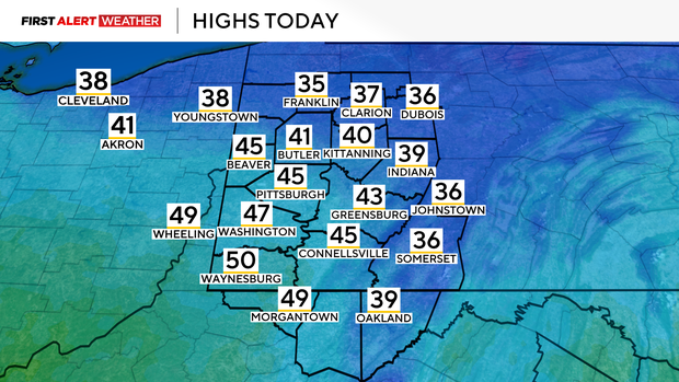
Getting back to Wednesday, morning lows dipped to the low 30s, similar to Tuesday. Unlike on Tuesday, we will start off with cloudy skies. We'd easily be in the 20s if it wasn't for the clouds. It'll once again be breezy on Wednesday with winds coming in out of the west-northwest at around 10mph-15mph in the afternoon. I have noon temperatures near 40 with a high of 45 degrees expected for Pittsburgh. You may see some snow (best chance north of I-80) but it shouldn't have any impact on area drivers.
WEATHER LINKS:
Current Conditions | School Closings & Delays | Submit Your Weather Photos