Strong storms with a possible tornado threat expected on Thursday in Pittsburgh

A severe thunderstorm watch has been issued for all of western Pennsylvania until 1 a.m. on Friday.
The watch also covers parts of Ohio and West Virginia.
There's a threat of tornadoes as a cold front slowly works its way through the area. The risk is low, with the Storm Prediction Center putting our chance at 2%. That's the lowest chance besides zero on their daily risk map. We hardly ever reach the 5% threshold.
The reason for our severe storm chance today is a cold front that will stall on top of us in the late afternoon into the evening hours. We should have a couple of hours ahead of the storms with sunny skies that will allow potential energy to build.
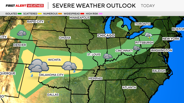
There looks to be just enough shear to mean we can't rule out a quick spin up or two. Our tornado risk is low.
Looking at the overall severe weather chance, I open up the window for severe weather at around 2 p.m. and keep the window open through midnight. The front will arrive as what we call a short wave, which should arrive along I-80 at 2 p.m., and the line of storms will slowly work its way to the south.
Storms that fire along the line, though, will be racing east. This means conditions can change rapidly. Any storm cells could have gusty winds and even some small hail. Frequent lightning should be expected with just how fast they're going to be moving. Downpours should also be expected, but unless we see storms training over the same area, our flood risk looks fairly low today.
While we wait for the storms, the weather is going to be surprisingly comfortable.
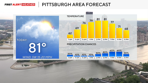
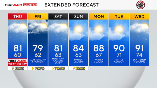
I have dew points in the low to moderate range all day long. It'll be sunny heading into the afternoon. I have highs hitting the low 80s with comfortable weather in place through at least 3 p.m. in Pittsburgh.
Morning temperatures dipped to the low 60s, with noon temperatures expected to be in the mid 70s.
Similar to today, most of Friday is expected to be dry. There will be another chance for rain on Friday, but rain doesn't arrive until after 8 p.m. Friday highs should hit the upper 70s. Friday's rain will stretch into Saturday morning, with rain continuing overnight and most rain ending before sunrise.
I can't rule out a scattered shower or two for the rest of the day on Saturday, but it's looking pretty nice and dry. I have Saturday's high hitting the low 80s, with highs going up to the mid-80s on Sunday. The area's first heat wave of 2026 is now expected to arrive on Tuesday.
I have highs in the 90s from Tuesday next week through at least Friday, with temperatures never dropping below 70° during that time period.