Pittsburgh's on and off snow comes to an end as the weekend approaches

PITTSBURGH (KDKA) - The end is near when it comes to these off-and-on snow showers that we have been dealing with for a little over a day.
WEATHER LINKS:
Current Conditions | School Closings & Delays | Submit Your Weather Photos
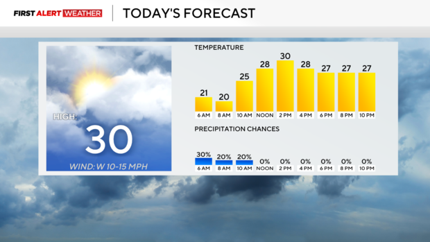
The last of the warnings and advisories that are in effect due to snow showers will come to an end at 1 p.m. this afternoon. There will still be a chance for snow even after the final warnings go away, but any additional snow should only have a minor impact on area roads.
Certainly good news there.
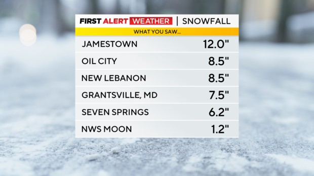
When it comes to totals, there were a couple of communities that saw well over six inches of snow. Most places though saw snow totals below 4". The Pittsburgh NWS offices located in Moon reported a snowfall total of 1.2".
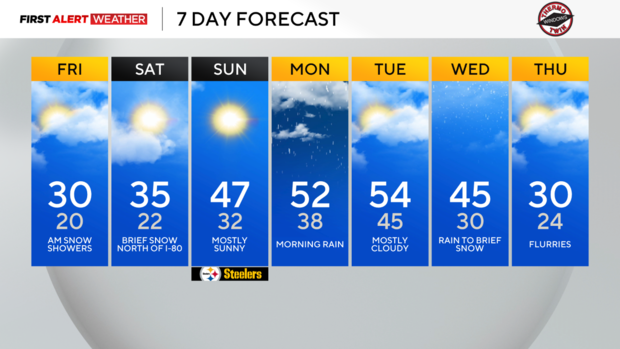
Looking ahead, temperatures will warm up this weekend with a warm front sliding through on Saturday afternoon. Saturday highs will hit the mid-30s. Sunday highs will be in the upper 40s.
The warmest days of the week will be on Monday and Tuesday with highs both days hitting the 50s. That's going to feel wonderful. There will be some rain around on Monday morning.
Monday afternoon is looking dry. Isolated showers will be possible on Tuesday with rain turning to snow happening on Wednesday. We will see another brief cool-down late next week before it becomes unseasonably warm.
Stay up to date with the KDKA Mobile App – which you can download here!


