Pittsburgh's stretch of sunny and seasonable fall weather lasts through the weekend

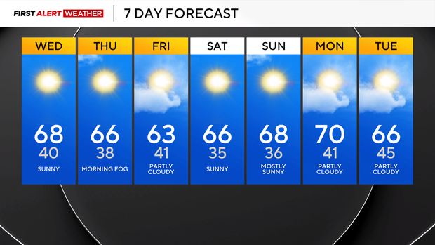
The calm weather pattern is set to continue through the weekend and beyond, with the biggest forecast challenge being how aggressive to go with high temperatures, with sunny skies and low humidity levels most days.
The temperature forecast will remain challenging over the next couple of days, with slight changes in the overall air mass's temperatures. While on the surface every day looks the same, 850mb temperatures show a difference of around 4°C from yesterday through Friday.
The 850 mb temperature is modeled to be at 9°C today during the afternoon. Model data says that is good for highs in just the low 60s. Modeling data on both Monday and Tuesday also showed similar forecast highs in just the low 60s. Both days saw highs well over that, with a high of 67° on Monday and 68° on Tuesday.
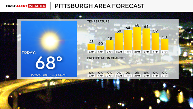
I am going to keep the 68° forecast high that I had yesterday for today's high. Morning lows will dip to near 40 degrees. I have noon temperatures in the low 60s with winds out of the northeast this afternoon between 5 - 10mph.
Particular focus should be paid to Thursday morning, with modeling showing conditions perfect for thick fog development. I expect some fog advisories to go into effect for Thursday morning with widespread dense fog development. Parts of Ohio are under a dense fog advisory this morning. I have morning lows on Thursday dipping to the mid to upper 30s.
Thursday highs should hit the mid-60s, with another sunny afternoon expected. What we call a 'backdoor' cold front will roll in on Friday morning, briefly bringing temperatures down to the mid-to-low 60s for highs.
We will see partly cloudy skies on Friday with the thickest clouds rolling through just before noon. Friday lows will stay in the 40s.
The weekend will be dry with highs in the mid to upper 60s on both Saturday and Sunday. Morning lows on both days will dip to the mid-30s.