Pittsburgh Weather: Approaching cold front to bring gusty winds, possible storm
PITTSBURGH (KDKA) -- A cold front approaches the region later Monday afternoon and evening.
ALERT: North and west of Pittsburgh this evening after sunrise will get a line of thunderstorms that could result in isolated damaging winds and potential hail.
AWARE: A cool down is on the way.
Monday's cold front is going to bring gusty winds this afternoon ahead of the rain around 20-25 mph. An isolated strong to severe storm is possible north and west of Pittsburgh around dinnertime, bringing the potential for damaging wind gusts near 60 mph and pea-sized hail. It will move out quickly by midnight and temperatures drop back at or below normal for our highs and lows through the week.
The coldest day of the week will be Wednesday with highs struggling to make it to 50 degrees. In the morning and afternoon, areas north of I-80 could see a flurry. There will be plenty of sunshine during the week but frosty mornings Thursday and Friday.
We warm back up near normal just in time for the weekend with sunshine. A few rain showers are possible Sunday.
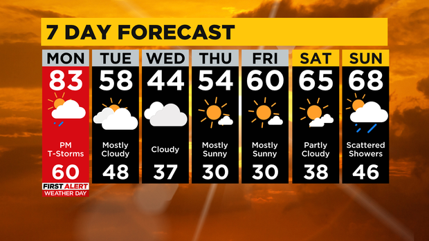
Monday: AM Sun, PM Rain/T-Storms
High: 83
Tuesday: Mostly Cloudy
High: 58
Wednesday: Mostly Cloudy
High: 44
Thursday: Partly Cloudy
High: 54
Friday: Mostly Sunny
High: 60