Pittsburgh looking at another round of light snow and cold air through the rest of the week
Yesterday's 3.8" of snow at Pittsburgh Airport places us 1.2" ahead of schedule for the winter. Most of western Pennsylvania and northern West Virginia received between 2-5" of snow with yesterday's fast-hitting system. Watch out for icy spots and areas of refreeze this morning, especially on untreated surfaces.
Low clouds remain prevalent across our area this morning and will continue to be widespread through noon.
WEATHER LINKS:
Current Conditions | School Closings & Delays | Submit Your Weather Photos
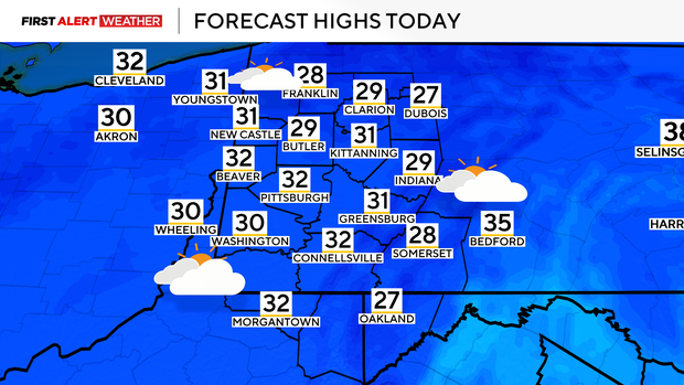
Some decrease in clouds is expected by late morning into the early afternoon hours as some dry air moves in from the southwest. Highs today will struggle to reach the freezing point thanks to a blanket of snow on the ground. More clouds will move in this evening and tonight ahead of another fast-moving disturbance.
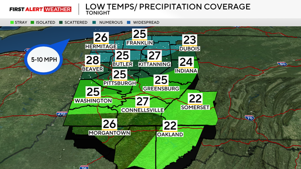
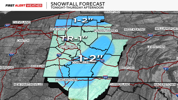
This system will not have much moisture to work with, but it will bring some light snow tonight into Thursday early afternoon.
The snow will begin between midnight and 3 a.m. for areas north of HWY 422 to I-80, and between 3-5 a.m. from the Pittsburgh metro area and points south into the Laurel Highlands and Ridges. This will be a lighter powdery snow compared to Tuesday's system, with most areas receiving 1" or less. 1-2" is possible north of the I-80 corridor and along westward-facing slopes and peaks of the Laurel Highlands.

A quick coating is expected on roads, and some minor visibility reduction is possible as the bands work their way through the area tomorrow morning. All snow should exit our region around 12 p.m. Winds will be brisk through the afternoon, around 15-20mph, then settle down by Friday morning as high pressure settles into the region. The lighter winds and clear skies atop a snowpack will allow temperatures to fall to the low teens with possibly a few single-digit readings.
Winds will be very light, so we're not concerned about wind chills deviating far from the actual air temperature, and it will not be dangerous.

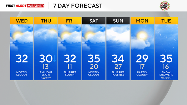
Southwest winds will increase through the day on Friday, allowing temperatures to slowly work their way back to near freezing during the afternoon hours with partly to mostly cloudy skies. A system will pass to our south on Friday with a few flurries possible south of I-70.
The overall pattern through the next several days will favor below normal temperatures and chances of intermittent light precipitation as a trough of low pressure remains centered across the Eastern US and Great Lakes states.
Stay up to date with the KDKA Mobile App – which you can download here!