It's going to be another mild Pittsburgh-area day ahead of weekend snow chances

It's going to be another mild day in the Pittsburgh area ahead of this weekend's snow chances.
Any alert days ahead? While probably no, interest in Friday to Saturday snow and just a general low comfort level for those stuck outside may be enough. The Pitt FB game is on Friday night
Aware: The last time Pittsburgh recorded measurable snow was on March 17th.
Sunshine fueled yesterday's high, which hit the mid-60s. We will continue to see winds out of the southwest, but skies will be mostly cloudy for a majority of the day. Clouds roll in right at sunrise at 7:03. Temperatures should still go up fairly quickly, with morning lows in the upper 30s.
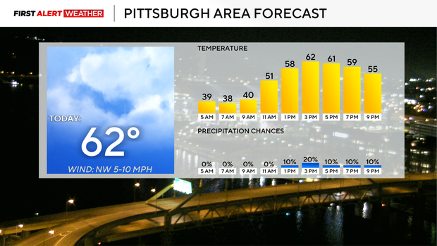
Noon temperatures are in the mid-50s, and highs today hitting the low 60s. I am bumping up the expected high to around 62° due to model data showing slightly warmer temperatures. Just a heads up that highs on both Thursday and Friday will be hit at midnight, with afternoon temperatures at least five degrees cooler in the afternoons.
Not much has changed with the Friday to Saturday snow chance. Isolated snow showers, mixed in with a cold rain, will impact the area mainly Friday afternoon into Saturday morning. The impact is only expected to be minimal at best due to the total amount, along with both surface air temperatures and ground temperatures. Currently this morning, satellite and radar imagery show a mid-level low rounding the base of the Arctic jet in Minnesota. The low will deepen to around 1000 mb as it moves in and stalls out just north of the jet stream. This low will pull winds from the north on its western side, with lake effect snow being our biggest issue now when it comes to winter weather.
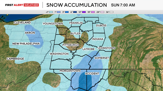
Temperatures will bottom out in Pittsburgh at around 31 degrees on Saturday morning. This will be the most hazardous time, with light rain and some snow possible. Temperatures in some places will dip into the 20s. This is a recipe for some slick spots that can't be ruled out on Saturday morning. Temperatures have been so warm going into this event that I don't expect widespread issues on roads, but if you don't have to be out, take your time getting out on Saturday morning.
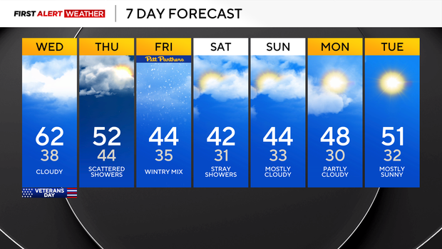
While snow will be measurable for places in higher elevations, it appears that at most you will see the grass briefly turn white before any snow melts fairly quickly. For most other places, light rain and some ice pellets falling will be what you see with this event.