Milder start to the week ahead of another brief cold snap with snow showers

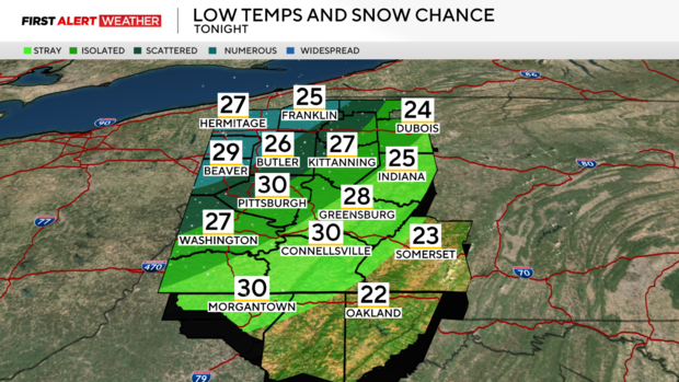
PITTSBURGH (KDKA) - Sunday begins with partly to mostly cloudy skies and along with areas of patchy dense fog. Mid and high-level clouds will continue to drift through our area this morning leading to mostly cloudy conditions. Some partial clearing skies are expected by Sunday afternoon as a short-lived region of high pressure settles in along with some drier air moving in from the southwest.
WEATHER LINKS:
Current Conditions | School Closings & Delays | Submit Your Weather Photos
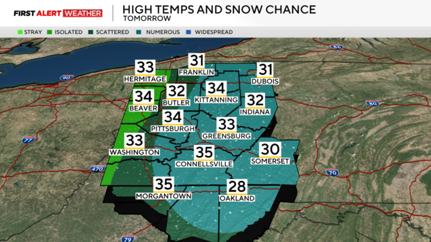
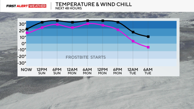
The next disturbance that is poised to bring a quick-hitting round of snow showers is moving through the Midwest this morning and will arrive in Western PA late tonight into Monday morning. Snow showers are likely for the morning commute time frame on Monday before activity generally shifts into the Laurel Highlands by the middle of the day. Some partial clearing skies may occur by Monday afternoon and evening, however, temperatures will actually fall through the day as strong cold air advection flows in from the west following the passage of a cold front. Highs on Monday will reach the low 30s in the morning before dropping into the teens by late evening. This drop in temperatures will also be accompanied by fairly strong winds and wind gusts. Gusts will likely range between 25-35 mph Monday afternoon into Tuesday morning with air temperatures dropping into the low teens and single digits. This could create a brief period on Tuesday morning where wind chills drop into the teens below zero, especially in the higher terrain where winds will be stronger. This range of wind chills is close to the level where frostbite could occur in 30 to 40 minutes, so cold weather precautions should be considered for Tuesday morning.
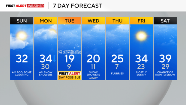
By Tuesday afternoon through Thursday, several weak disturbances aloft in the atmosphere and very cold air flowing aloft a relatively ice-free Lake Huron and Lake Erie, will result in chances of lake-effect snow showers and general snow showers. For Tuesday morning through the middle of the day, winds aloft should be more westerly which should keep most of the lake-effect snow concentrated over our northern counties and mainly north of I-80. By Tuesday evening into Wednesday morning, the bands may shift farther south into the region which could bring a couple bands of light accumulating snow into the Pittsburgh metro area. Highs will be in the upper teens to low 20s with lows in the single digits to low teens.
Winds will begin to shift to the southwest on Thursday, which will start a warming trend to carry us into the upcoming weekend. Expect high temperatures to reach the low to mid 30s on Friday, and possibly 40 by Saturday before another strong cold front arrives late Saturday night into Sunday with more rain and snow possible.
Stay up to date with the KDKA Mobile App – which you can download here!


