Isolated severe storms possible on Thursday, summer weather returns soon in Pittsburgh

Two waves will kick through our area today, potentially triggering rain and storms. The first wave will have rolled through by the time you're reading this, with isolated to scattered storms rolling through just ahead of the busiest part of the morning rush.
The next wave moves through during the early afternoon hours. This is where our severe weather chances will occur if they happen. Model data is showing little to no rain or storms happening during this time, but modest instability will be in place.
We are holding off on going into First Alert mode for now due to the low potential for storms and, honestly, rain at this point for your afternoon.
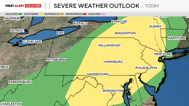
Storm chances rise for communities east of the Laurel Highlands. Strong wind speeds would be the main concern for the afternoon with any storms that develop. We are starting to get into our late-summer hail season, and hail can't be ruled out along with a brief spin-up.
The Storm Prediction Center puts the chances of any spot 30 miles around a point seeing large hail or damaging wind at around 5 percent. Our tornado risk is lower than 1 percent in the same defined area.
It really looks like the wind and hail risk is too high at this point.
While you should certainly be weather-aware today, the day overall is looking pretty good.
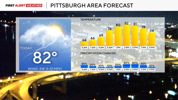
I have highs today hitting the low 80s with partly cloudy skies. Morning lows dipped into the mid 60s. Humidity levels will tick into the moderately high range, with dew points ticking up to around 66° this afternoon. Highs today will be near 80 degrees like yesterday.
Yesterday's Pittsburgh high hit 80 degrees, which is what I forecast. Second day in a row that I have been spot on with our highs. I am forecasting a high of 82 degrees today.
I have storm coverage for today at around 40 percent at the peak, which will likely happen before 8 a.m. I have an isolated 30 percent rain chance in place for Friday still too.
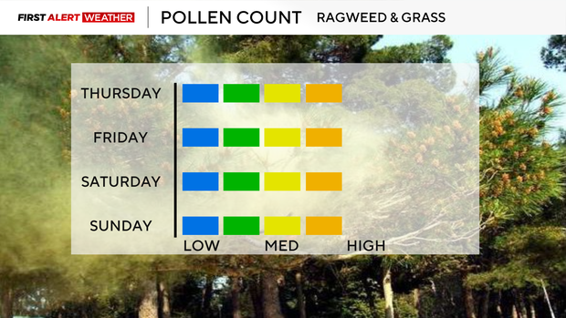
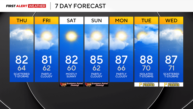
Besides that, the rest of the weekend is looking dry and pleasant for outdoor activities. I have Friday's & Saturday's highs hitting the low 80s, with highs in the mid-80s on Sunday. Humidity over the weekend will be moderate to low.
Next week will see us on the northeastern edge of a powerful late summer ridge that will push our 850mb temperatures up to 20° Celsius at times next week. If conditions all hit right, or wrong depending on what you like, we could see a random 90° day being hit next week.
I am going to keep highs in just the mid to upper 80s for next week, with the hottest days coming on Tuesday and Thursday, when I am forecasting highs hitting 88°.