Heat index could reach into the 100s on Wednesday along with possible strong storms | First Alert Weather

Severe weather will remain possible today, with the biggest concern coming in the form of fast-moving storms with winds of up to 80 mph on the leading edge. Most of your day will be dry, with conditions changing quickly when storms roll through.
The highest chance for severe storms will be near where storms developed yesterday, along and north of I-80, along with places in the ridges of Westmoreland County and Fayette County to the east. There is a chance you won't see a drop of rain today and will get to enjoy hot and humid weather from start to finish.
You'll be in the minority, though.
When it comes to today's setup, we continue to have a powerful ridge of high pressure parked to our southwest. This ridge is pushing temperatures up into the mid-summer range, with a number of places in the south, midwest, and plains seeing highs soaring to the upper 90s.
We also have a progressive trough just off to our northeast with temperatures below average for a big chunk of the New England states. We are right in the middle with the jet stream parked right on top of us. This puts us in an area conducive to wind storms due to the northwest-to-southeast alignment of the jet on top of us.
Model data has us seeing different levels of storms, with the NAM 4k model being the more aggressive, with two clear lines of wind storms coming through, with the first happening this morning around the morning commute. The HRRR keeps most of Western Pennsylvania dry for the day.
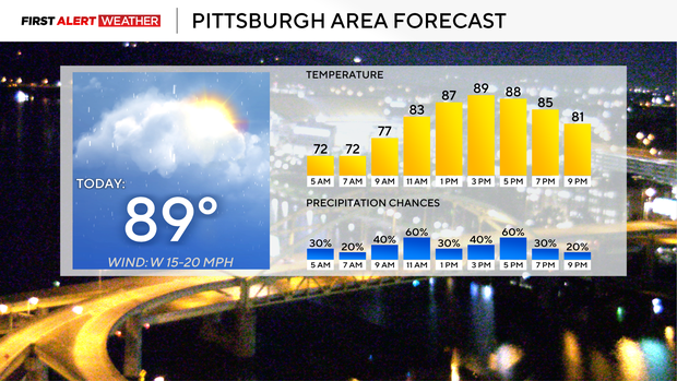
The latest run of the GRAF model splits the difference, with storms occurring for places east and north of Pittsburgh. The GRAF is likely the most accurate at this point. Windstorm wave chances look to peak around 9 a.m. to noon today, with a second line possible from 3 p.m. to 6 p.m. Storm chances will continue through Friday morning.
The other big story comes in the form of heat in place today.
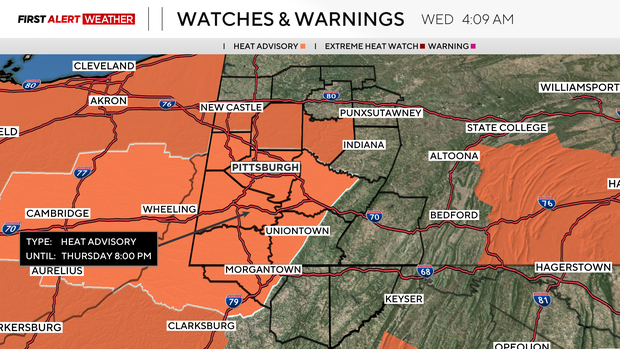
The NWS has issued a Heat Advisory for a big chunk of our area due to heat, calling for heat index values as high as 102°. I don't think we get anywhere close to 100° for our heat index today, but it will be hot, and it will be humid. If you are stuck outside for the day or don't have the luxury of an A/C unit, it may be uncomfortable for you at times today.
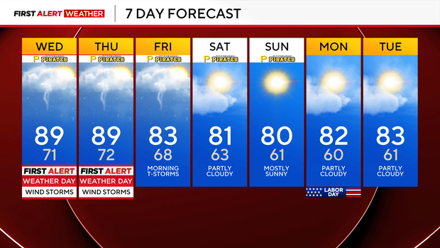
Frequent breaks if working, staying hydrated, and even taking a shower when you can will help to make things a bit more bearable for you. Today will be the hottest day of the week, but highs will be near 90 again on Thursday.
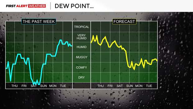
Quickly, your holiday weekend is looking comfy, with highs on Saturday through Labor Day in the low 80s and morning lows near 60. Besides a small chance of a passing morning shower on Saturday, the weekend is looking dry.