Has Pittsburgh seen its final 90-degree day of the year? Here's the latest forecast data

The forecast over the next week points to near-normal to slightly below-normal temperatures. With school back and pumpkin-spiced everything making its return over the next week by various national franchises, you have to ask: is summer-like weather over?
To me, nothing really says 'summer' like a really hot and sweltering day. My forecast doesn't have one of those in the forecast over the next seven days + two. That puts us at the 28th of August with no ''summer-like' days. For the sake of this argument, let's call a 'hot' day a day with highs at or above 87°.
That's pretty generous, right?
While I am sure we will see highs hitting the upper 80s again before fall weather settles in for good, I am not so sure about 90° weather. Historically, we average around 3 -4 90° days in August. Just 1 - 2 in September, so historical averages do point to us still having a 90-degree day.
Here's the thing: while August temperatures are running 1.6° warmer than average, we have not seen a 90° day this month. The hottest we have gotten is just 86°.
One of the reasons we have failed to hit temperatures above 86° so far this month is the high humidity levels we have seen, along with so many rain days. As humidity comes down and our pattern settles, we should see more highs well above the average temperature. That's something we haven't seen much of.
I do expect we will see at least one, if not 2 - 3, 90-degree days over the next 30 days. The Climate Prediction Center will push out their monthly September forecast over the weekend, but looking at the data, it is likely going to keep us as having a higher-than-normal chance of seeing September warmer than average.
This would also be in line with their 3-month forecast that has August-September-October as likely being warmer than normal.
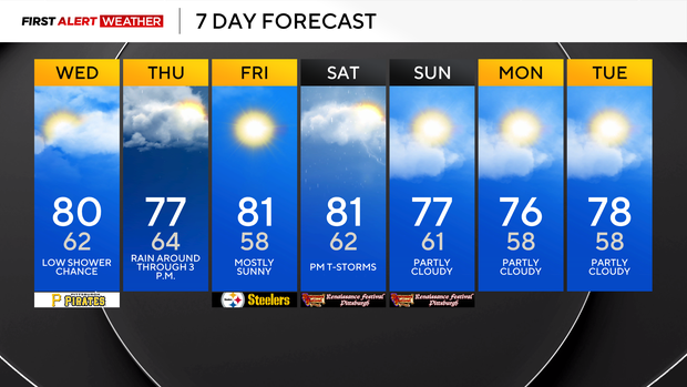
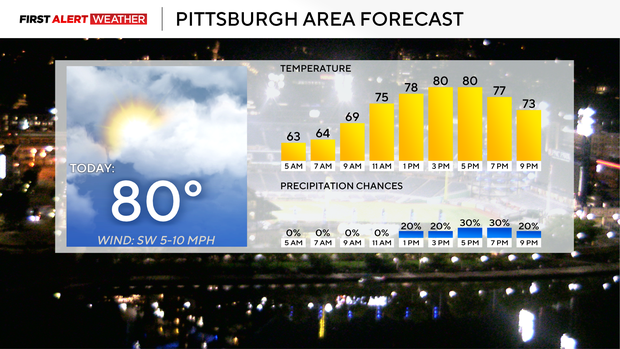
Getting back to your forecast, I have only an isolated chance for rain in the forecast today, meaning almost everyone, if not everyone, will be dry. Most will see rain on Thursday morning as a surface low rides along and just ahead of a cold front pushing through. This will be our best chance for rain for the rest of the week.
There will also be a chance of rain and potentially a storm on Saturday.
I have highs today hitting 80 degrees with mostly cloudy afternoon skies. Winds today will be light and out of the southwest. Looking ahead, I have a slew of near 80-degree days on the 7-day forecast with not a lot of variation. Over the next 9 days, I have the warmest daily high coming in at 81° and the 'coolest' high temperature coming in at 76°.
I have a couple of mornings falling to the mid to upper 50s.