Severe storm risk in place for the Pittsburgh area with flood risk on Thursday morning

A severe thunderstorm watch is in effect for parts of the Pittsburgh area until 11 p.m. on Wednesday.
In the Pittsburgh area, the watch covers Armstrong, Butler, Beaver, Lawrence, Allegheny, Washington, Westmoreland and Indiana counties. It's also in effect for other parts of Pennsylvania, New York, Ohio and West Virginia.
The storms also brought a tornado warning for parts of Beaver County around 7:30 p.m., but it has since expired.
Risk of severe storms
There's a slight (level 2 out of 5) risk of severe storms for parts of western Pennsylvania on Wednesday. Everyone else is under a level 1 marginal risk. Parts of the area are under a slight (level 2 out of 4) risk of flash flooding Thursday morning. Everyone else is under a level 1 marginal risk.
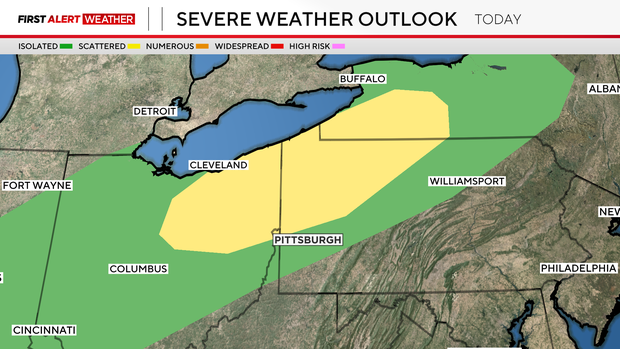
A cool front rolls through Wednesday night, bringing with it a chance for severe storms and flooding. The Storm Prediction Center has parts of our area from Pittsburgh to the north under a slight risk of severe storms (level 2 out of 5) for this evening and early Thursday morning. Strong winds are the main concern, but any time you have wind storms, you can't fully rule out a quick spin-up.
There is also a risk for flash flooding, with the Weather Prediction Center having parts of our area from I-70 to the south under a slight risk (level 2 out of 4) for 'excessive rain' that could lead to flooding.
Timing of severe storms
Rain and storm chances will pick up after 6 p.m., with places along I-80 seeing isolated shower activity and the line of storms up around Cleveland. At 8 p.m., storms will start to roll through Mercer and Vanago County.
Storms will cross I-80 around 10 p.m. and will arrive in Pittsburgh shortly after midnight. The strongest storms should occur between 9 p.m. and 1 a.m. Rain chances will remain with general storms after 1 a.m., with the heaviest rain located along and just south of I-70.
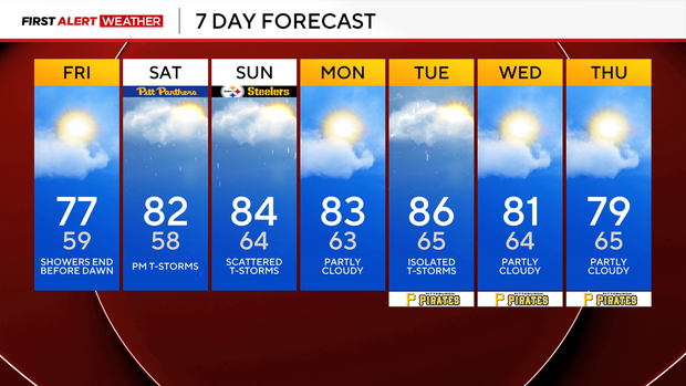
Rain and some thunderstorm activity will return on Thursday afternoon, as the cool front stalls on top of us with rain chances ending early on Friday morning. There will be some storms around Saturday late in the afternoon, and some more activity is also expected late Sunday.
When it comes to temperatures, highs will dip to the upper 70s for Thursday and Friday. Highs on Saturday and Sunday should be in the mid-to-low 80s.