Widespread, moderate-to-heavy snow this evening tapers to snow showers on Sunday | First Alert Weather

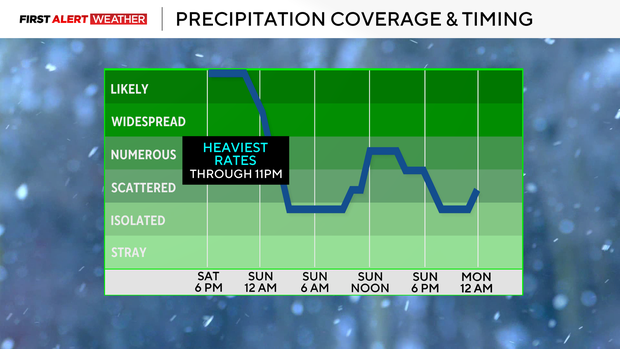
Snow moved in right on schedule, and we are now moving into the part of the event where the heaviest rates are expected.
Winds converging weakly in the mid-levels of the atmosphere will focus one or several narrow west-to-east-oriented heavy bands of snow generally near or just south of the Pittsburgh metro to I-70/I-68 corridors this evening through 11 p.m.
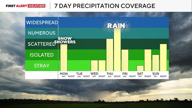
The steady, widespread snow will slowly taper from northwest to southeast between midnight through 4 a.m. Sunday with lingering flurries and snow showers. Lake-effect snow showers are expected to increase in coverage after sunrise and persist most of Sunday into Monday morning. Most of these will impact the I-80 to Route 422 corridors, but it is likely some of these bands—especially if we get a solid fetch off of Huron as well—will make it into the Pittsburgh metro area, leading to locally higher amounts and reduced visibility.
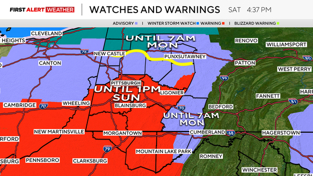
A lake-effect snow warning is in effect for Mercer and Venango counties to account for this.
WEATHER LINKS:
Current Conditions | School Closings & Delays | Submit Your Weather Photos
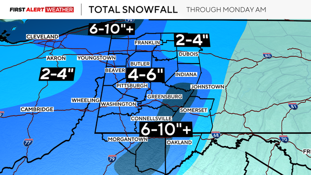
Some upslope enhancement, plus these bands, will result in a modest 6-10" with isolated 12" amounts in the peaks of the Laurel Highlands and westward-facing slopes of the Ridges.
A majority of our area, including the Pittsburgh metro, should cap off with a range of 4-6" for total event snow out of this system. If we reach 5.6" of snow before midnight Saturday, that would tie a daily snowfall record for the airport, so we'll keep an eye on this.
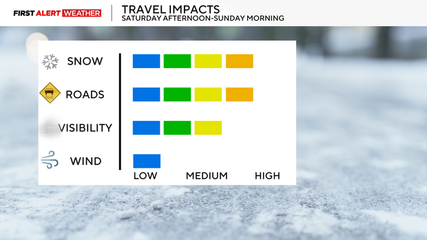
The lowest amounts are expected to occur over our northeast counties with 2-4" for parts of Jefferson, Clarion, and Forest counties. Expect travel impacts with snow-covered roads, reduced visibility, and some minor wind gusts, but wind overall is not a major threat with this system for most areas.
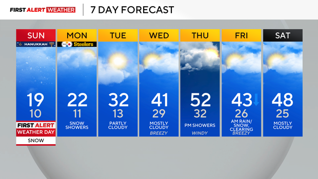
On Monday, another disturbance will move in from the northwest in the wake of the departing system for Sunday. This will lead to more scattered snow showers and light accumulation, especially north of Pittsburgh toward the I-80 corridor.
Temperatures will be as much as 20 degrees or more below normal to start the week, but a rebound is expected by midweek with highs reaching the low 40s on Wednesday and 50s by Thursday. This warm air will surge north, accompanied by strong winds ahead of what will likely be another strong low-pressure system to bring mostly rain Thursday into Friday.
High winds are possible with this system, so they will need to be monitored. Temperatures will cool slightly behind this system toward the end of the week, but not as cold as we've been the last few weeks.
Stay up to date with the KDKA Mobile App – which you can download here!