Pleasant weather on tap for Christmas Day in Pittsburgh area as snow, ice and sleet loom
Pleasant weather is on tap for Christmas Day in the Pittsburgh area, as the possibility of snow, ice and sleet looms ahead of the weekend. Here's a look at the western Pennsylvania forecast for Christmas Day and into the weekend.
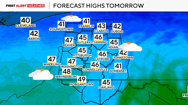
Christmas Day forecast for Pittsburgh area
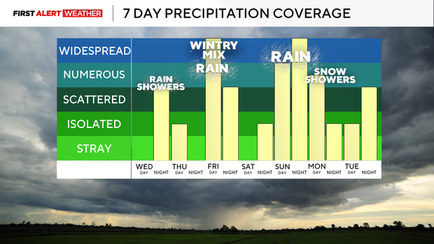
Two disturbances will impact the Pittsburgh area for the end of the week and into the start of the weekend. The first of which passes through late Wednesday night into Christmas morning. Showers are expected between 1 a.m. and 9 a.m. on Thursday, with the highest chance generally over the southern parts of western Pennsylvania.
An isolated thunderstorm is also possible in the southernmost counties. Most of the rain will exit by 9 a.m., with clearing skies anticipated through the rest of Thursday.
Snow, freezing rain and ice expected Friday
Widespread precipitation is expected across the Pittsburgh area between sunrise and noon on Friday.
Initially, this will fall as sleet and possibly snow. But as a mid-low level warm layer deepens, freezing rain will become the predominant precipitation type, especially for areas north of U.S. Route 422/Interstate 80 and into the Laurel Highlands and central Pennsylvania.
A winter storm watch is in effect for Armstrong, Venango, Indiana, Clarion, Jefferson, Forest, Westmoreland, Garrett, Somerset and Fayette counties, where confidence is highest in a prolonged period of sleet and freezing rain that will lead to a quarter-inch to half-inch of ice accumulation on Friday.
Minor damage to tree limbs, power lines and ice on untreated road surfaces is likely to occur in these locations.
Farther south and west, including the Interstate 79 corridor and Pittsburgh metro area, a brief period of freezing rain is likely to occur mid-morning through early Friday afternoon before warmer air moves in from the southwest later in the evening, allowing for rain to be the predominant precipitation type.
A tenth of an inch of ice or less is possible for most of the metro area.
While this is the most likely scenario to occur, the KDKA Weather Center will be closely monitoring wind direction and dew points. If the winds in the Pittsburgh metro stay easterly longer and the dew points are a tad lower, this will allow subfreezing temperatures to persist longer locally, which would lead to more ice accumulations.
Areas south and west of the Pittsburgh metro are expected to receive rain and possibly a thunderstorm for most of the day on Friday. Temperatures south of Interstate 70 may reach the low to mid-50s.
Weekend lookahead
This entire system will depart Saturday morning, with lingering clouds and light winds most of Saturday as high pressure moves in.
Southwesterly winds will increase on Sunday ahead of a strong area of low pressure and storm system moving in from the Midwest. This will allow warm air to surge in, with temperatures reaching the mid-50s.
Rain and thunderstorms are likely Sunday afternoon, evening and overnight. Models have trended toward a slower passage of the cold front with this system, so Monday's high will occur early in the day in the mid-to-upper 50s, followed by rapidly dropping temperatures later in the day. Rain will switch to snow showers as well.