How much snow could Philadelphia get this weekend? Totals depend on storm's track

A major winter storm is headed to the Philadelphia region. One of the biggest questions with the storm is just exactly how much snow the area will see. As of Thursday, the probability of the region receiving at least 6 inches was at 100%.
Looking ahead to Sunday and Monday, here's everything we know about the inbound snowstorm.
Current snow start times
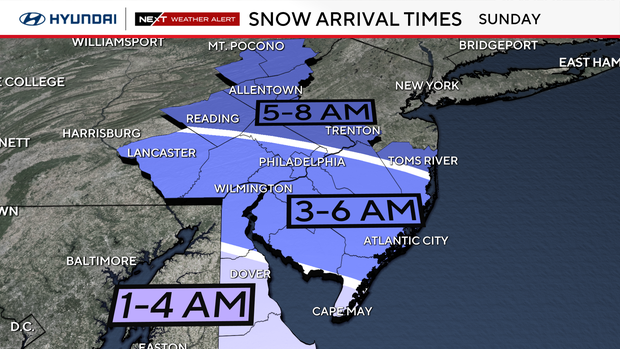
1-4 a.m.: Snow begins south and east of the city across southern Delaware and far South Jersey
3-6 a.m.: Snow begins across the I-95 corridor, Philly, interior South Jersey, Chester, Delaware, New Castle, lower Montgomery and lower Bucks counties
5-8 a.m.: Snow begins for upper Montgomery, Bucks, Berks, Lehigh Valley and Poconos.
The European Model (ECMWF) has snow beginning around midnight Saturday and lasting through pre-dawn Monday morning, with light snow showers through early Monday morning.
The American Model (GFS) has snow beginning after midnight Sunday morning and lasting through Monday afternoon, with light snow showers into the evening.
There may be some blowing and drifting snow throughout the day on Monday, complicating travel and snow removal.
How many inches of snow will we get in the Philadelphia area?
As of Saturday morning, here's how our model runs are looking in terms of total snowfall across Pennsylvania, New Jersey and Delware.
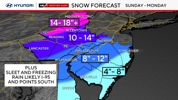
- 4-8 inches: Kent County, Delaware; Cape May County, Atlantic County, southern Burlington and Ocean counties in New Jersey
- 8-12 inches: Philadelphia, Delaware County, lower Bucks and Montgomery counties in Pennsylvania; New Castle County, Delaware; Salem, Gloucester, Camden, northern Burlington and Cumberland counties in New Jersey
- 10-14 inches: Lancaster, Chester, Upper Bucks, Upper Montgomery, lower Berks/Lehigh counties in Pennsylvania; Mercer County in New Jersey
- 14-18 inches: farthest points north in our area: Upper Berks/Lehigh/Northampton counties; the Poconos
The last time Philadelphia saw a 6-plus inches snowfall in Philadelphia was 7.5 inches on Jan. 29, 2022.
The last time Philadelphia saw 12-plus inches was 22.4 inches on Jan. 22-23, 2016.
The last time Philadelphia saw more than 24-plus inches of snow was 28.5 inches on Feb.5-6, 2010.
Heaviest snowfall times
Snowfall will be light at the start, early Sunday morning, and increase through the morning.
The storm will intensify by late morning through the afternoon and Sunday night. That is when the heaviest snowfall will occur.
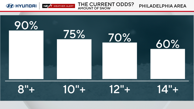
As of Thursday, the probability of 6 inches of snow is now at 100%, and the probability of 12 inches of snow is 70%.
Sleet and freezing rain possible on top of heavy snow
At some point in the evening, a layer of warm, moist air will be drawn into the storm, and there may be a change to sleet and freezing rain from I-95 to the shore and across Delaware.
This will fall on top of already high amounts of snow. There may even be a period of rain on the beaches.
The question is, how much and for how long there will be any sleet/freezing rain. This could make the difference between 6-8 inches of snow and 12-16 inches of snow.
If the center of the storm runs closer to the Jersey Shore, we will see more sleet and freezing rain. The snow totals would be on the lower side of our forecast.
If the storm tracks 50-100 miles farther offshore, we will see mainly all snow and little if any sleet/freezing rain. The snow totals would be the high side of the forecast.
Snow ratios
This weekend will be the coldest air of the season yet, and any snow that falls will be at a high snow/water ratio due to the cold.
Meaning, the colder the air, the more snow is squeezed out.
A 20:1 snow ratio means 20 inches of snow would be produced from 1 inch of water. In comparison, so far this season, we have seen wet snow with ratios of 6:1 and 8:1.
We will be in a cold enough and dry enough atmosphere to support a 20:1 ratio for light, fluffy snow.
So, if there is a half inch of water in the atmosphere, we will see 10 inches, if there is a quarter inch of water, we will get 5 inches, and if there is three-fourths of an inch of water, we will see 15 inches.
Storm impacts
Power outages, airport cancellations, train delays, dangerous roads, trees down, school closings and office building closings.
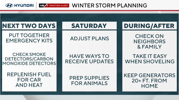
Please remember special care for your pets, check on neighbors and friends, keep space heaters away from furniture and drapery, and never use a generator for heating indoors.
Temperatures will plummet Monday through the middle of next week, with highs in the low 20s and overnight lows dipping to single digits and below zero. So, plan on this snow sticking around through the end of the month.
The best advice is to stay with the NEXT Weather Team for frequent updates, each day to plan and prepare for the weekend. Have the shovels and ice melt ready. This could be the heaviest snow of the season.