Cooler and seasonable Monday in Philadelphia region as heat wave ends. Here's the weather forecast.

Our most recent heat wave has ended, and we start the new week with sunshine, lower humidity, lighter winds and cooler temperatures.
On Monday, enjoy the cooler and more seasonable air with highs in the upper 70s to to nearly 80 degrees.
Tuesday is also pleasant with sunshine and temps in the low to mid-80s.
By Wednesday, the heat begins to creep back into the area, and another heatwave takes hold Thursday through the weekend with highs in the low to mid-90s.
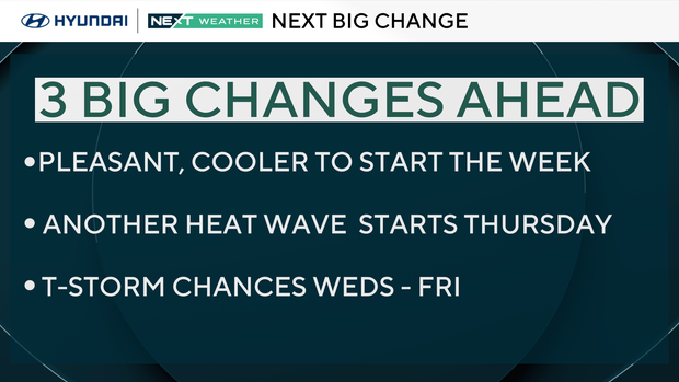
NEXT big weather changes
Showers and storms are likely through the day Wednesday as a warm front lifts through the region and puts an end to the comfort.
Heat wave number three of the year arrives by Thursday with highs in the mid-90s through Friday. The heat rolls through next weekend and it's not even summer yet!
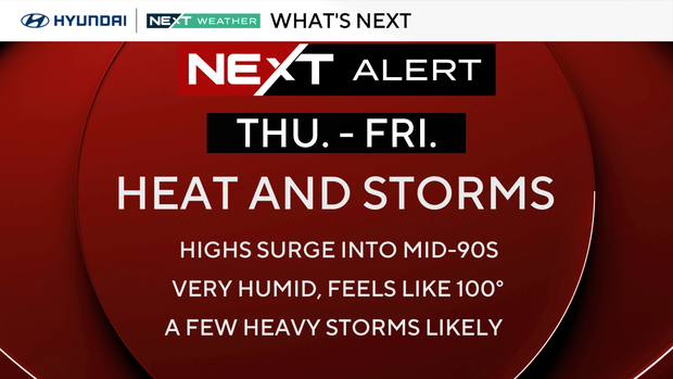
Heat index values may approach or exceed 100 Thursday and Friday, so we've issued a NEXT Weather Alert for both days. Storms will fire up each afternoon and some could turn locally strong.
FYI: Summer officially begins on Sunday, June 21, at 4:24 a.m.
Here's your 7-day forecast:
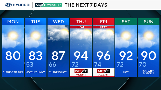
Monday: Clouds to sun. High 80.
Tuesday: Mostly sunny. High 83, low 53.
Wednesday: Turning hot. High 87, low 66.
Thursday: NEXT Weather Alert. High 94, low 72.
Friday: NEXT Weather Alert. High 96, low 74.
Saturday: Hot. High 92, low 72.
Sunday: Isolated thunderstorm. High 90, low 70.


