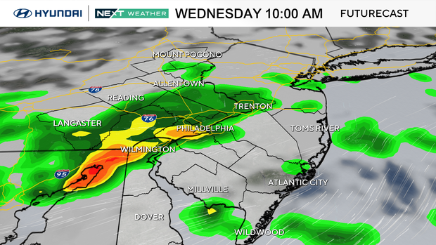
Tracking rain in the Philadelphia area today: scattered showers, possible thunder in the weather forecast
While not a washout like the past weekend, keep your umbrella on standby as passing showers and storms will be moving through the area during the first half of the day.
A severe thunderstorm warning has been issued for parts of South Jersey until 1 p.m.
Despite the clouds and showers, it remains a shorts and T-shirt day with high temperatures near the 80-degree mark for all locations.
We will likely see the sun break out in the afternoon, gradually from northwest to southeast.
NEXT big weather changes
After Wednesday, the next big change is the LACK of a big change (finally).
High pressure will bring lots of sunshine from midday Thursday through the weekend, and a surface cold front Friday night will knock the temps down just slightly for the weekend.
Both weekend days look great, with highs in the mid-70s and lots of sun to close out the month of May on (finally!) a seasonable note.
We think we've earned it! Keep this in mind — last Tuesday was a record high of 98 degrees.
Not only a record for the day, but the hottest temperature ever recorded in May and the earliest 98 degree temp ever recorded in Philly.
Then, just four days later, the high was just 57 degrees on Saturday, which is one degree away from the COLDEST high temperature for the day. Talk about a rollercoaster ride.
Here's your 7-day forecast:
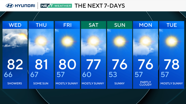
Wednesday: Showers. High 82, low 66.
Thursday: Some sun. High 81, low 67.
Friday: Mostly sunny. High 80, low 57.
Saturday: Mostly sunny. High 77, low 60.
Sunday: Sunny. High 76, low 53.
Monday: Partly cloudy. High 76, low 57.
Tuesday: Mostly sunny. High 78, low 57.


