Heat wave underway in Philadelphia with highs in the 90s Tuesday. Here's the weather forecast.

A NEXT Weather Alert is in effect from Tuesday until Sunday as extreme heat arrives in the Delaware Valley.
We managed to eke out a high temperature of 90 on Monday, so the "heat wave" — as traditionally defined in our area by three or more days above 90 — is underway. It won't be "official" until we hit 90 on Wednesday.
High temperatures Tuesday will reach a manageable 92 degrees, but Wednesday, Thursday, Friday and Saturday are the dangerously hot days.
Philadelphia is under a heat health emergency from 11 a.m. Wednesday through 8 p.m. Saturday, the city announced Tuesday.
The PCA Heatline (215-765-9040) will be available between 8:30 a.m. and 8:30 p.m. during the emergency, according to the city. City health department nurses will be available to speak with callers about medical problems related to the heat.
This map on the city of Philadelphia's website shows cooling center locations, which will be open during the emergency. Residents are also encouraged to visit any of the over 150 Philadelphia Parks & Recreation's spraygrounds and pools.
The city's older adult centers all have air conditioning and are open between 4 p.m. and 7 p.m., Monday through Friday, and 12 p.m. and 5 p.m. on weekends.
NEXT big weather change
If a heat wave is three days above 90 degrees, we may need a new term for a stretch of days above 100 — a heat tsunami, perhaps?
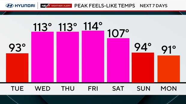
An extreme heat warning goes into effect at noon Wednesday until 8 p.m. Saturday. High temperatures will range from 99 to 104, but the high humidity will make it feel like 105-110-plus.
While we have endured three heat waves already this year, this one looks likely to be historic and unprecedented.
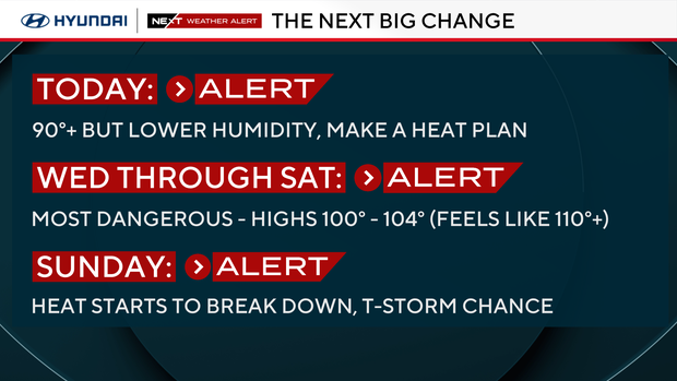
If our current forecast high temps hold, that would give us a four-day stretch of highs above 100, which has never happened on record in Philadelphia. The record highs each day are 100 or above, and we may tie or break some of them.
Thursday and Friday are likely to break daily heat records, with Thursday's record of 103 dating back to 1901 — 125 years, or half the time America has existed.
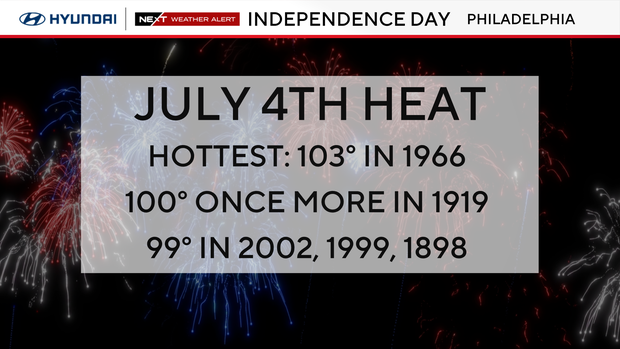
Our forecast high of 100 on Independence Day would tie for the second hottest July 4th ever — only twice have we had 100+ highs on the Fourth of July. And if we hit our forecast high of 105 on Friday, it would be the hottest July temperature ever recorded in the city (hottest temperature overall is 106 in August 1918).
That's a lot of records to contend with, and should hopefully convey the rarity and danger this hot stretch presents.
Wednesday, Thursday, Friday, and Saturday are the dangerously hot days. Highs 100-105 with heat index values each afternoon peaking around 110-115.
Pop-up afternoon and evening thunderstorms are possible each day due to the heat and humidity. Any rain could keep some locations in the upper 90s rather than 100s.
We'll also monitor for spotty storms to form along a sea breeze boundary as the Jersey Shore stays cooler than inland areas.
Scattered storms are possible late Saturday, but as of now, it doesn't appear to be a widespread severe event. Sunday brings another chance for scattered showers and storms as the heat begins to break down.
Code Orange air quality alert in Philadelphia area
Several counties in the Philadelphia region are under a code orange air quality alert Tuesday. Health and environmental agencies say the heat and sunshine will cause a buildup of ozone Tuesday afternoon.
This alert means air quality may be unhealthy for sensitive groups, including the elderly and people with respiratory conditions. If you're in one of those groups, you should avoid heavy outdoor activity.
Plan and prepare for the heat
Have somewhere cool to rest, special care for pets, check on neighbors and family, limit time outdoors, check fluid in cars and keep hydrated.
Swimming pools, movie theaters and shopping malls are places to stay cool.
Cars become death traps in the heat. No people or pets should ever be left in the car. The heat can reach 125 degrees in minutes and cause death. Check your back seat before leaving a car.
Buildings with no air conditioning will heat up and retain the heat. That cumulative effect of the heat after 3-5 days could be deadly for some.
Our heat records since 1894
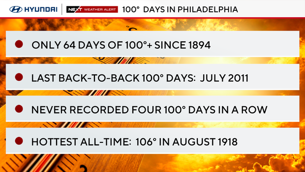
- There have only been 64 100-degree days in Philly since 1894 (per the NWS).
- We've had only one 100-plus day in 14 years. That was last June 24, 2025.
- The hottest day on record for Philly is 106 on Aug. 7, 1918.
- The hottest July temperature on record is 104 on July 3, 1966.
- Back-to-back 100-degree days have only occurred 14 times. The last back-to-back 100-degree days were in July 2011.
- Three consecutive 100-degree days have only happened twice in Philly history, during July of 1993 and July of 1966.
- We have never had four consecutive 100-degree days.
- Records we are chasing: July 1 record is 102 from 1901, July 2 is 103 from 1901, July 3 is 104 from 1966.
Here's your 7-day forecast:
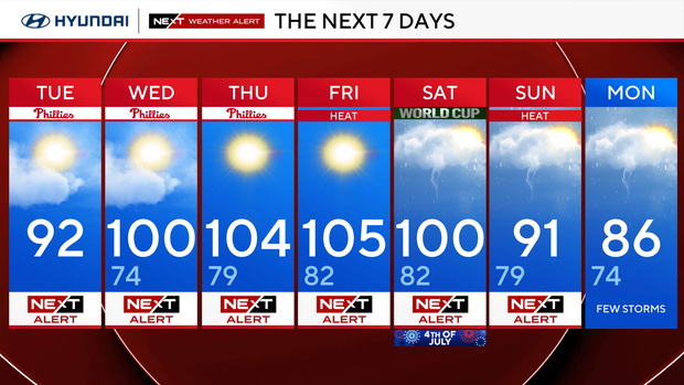
Tuesday: NEXT Weather Alert. High 92.
Wednesday: NEXT Weather Alert. High 100, low 74.
Thursday: NEXT Weather Alert. High 104, low 79.
Friday: NEXT Weather Alert. High 105, low 82.
Saturday: NEXT Weather Alert. High 100, low 82.
Sunday: NEXT Weather Alert: High 91, low 79.
Monday: Few storms. High 86, low 74.