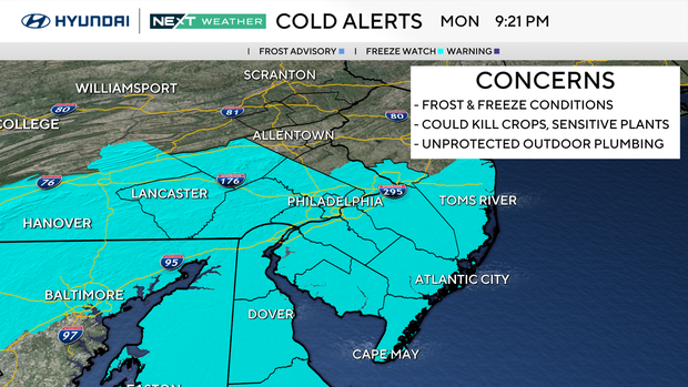
Cooler than normal Tuesday in Philadelphia region, freeze watch issued for Wednesday. Here's the forecast.
Despite plenty of sunshine, a reinforcing push of cooler air will hold temperatures between five to seven degrees colder than normal in the low-middle 50s on Tuesday afternoon in the Philadelphia region.
To add to this early April chill, temperatures will feel like the 40s through the afternoon, thanks to a breezy northwesterly wind from 10-15 mph, gusting to 30 mph at times. As the sun sets Tuesday evening, it turns even colder as temperatures start to plummet through the overnight.
NEXT big weather changes
Temperatures Tuesday night will dip into the upper 20s and low 30s, which has prompted a freeze watch for most of the region on Wednesday morning from 12 a.m. until 9 a.m. These freezing temperatures could cause a little damage to some of the early-season growth we have already started to see.
The good news is that the cold will be very short-lived as temperatures make their way back into the 60s on Thursday and then 70s for Friday and Saturday.
Here's your 7-day forecast:
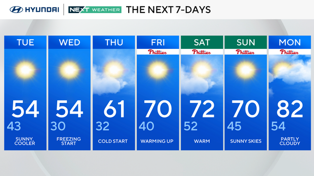
Tuesday: Sunny and cooler. High 54, low 43.
Wednesday: Freezing start. High 54, low 30.
Thursday: Cold start. High 61, low 32.
Friday: Warming up. High 70, low 40.
Saturday: Warm. High 73, low 52.
Sunday: Sunny skies. High 70, low 45.
Monday: Partly cloudy. High 82, low 54.