Temperatures will be more seasonable Tuesday in Philadelphia region. Here's the weather forecast.
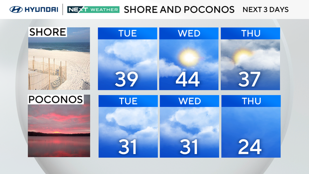
Starting Tuesday, the Delaware Valley will warm above freezing each day to the mid- and upper 30s, with the low 40s possible for some.
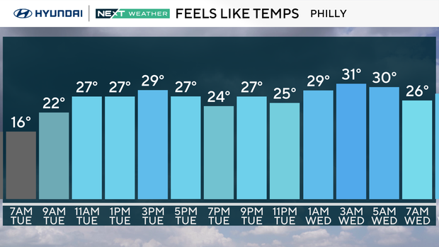
Overnight lows will be milder too, with lows in the teens Tuesday morning and then in the 20s and 30s through the remainder of the week.
If we reach the 40s Tuesday, it will be the first time since Jan. 23 — 18 days ago! The average high for that entire length of time is 40 degrees, but we've been locked well below that.
NEXT big change
While the temps above freezing will allow for some snow and ice to melt during the day, the return below freezing overnight will produce a daily risk for icy morning conditions.
A cold front moving through Tuesday night will bring a few spotty showers, but any rain will be out by Wednesday's commute.
Wednesday stays mild, with another shot at 40 degrees, before turning windy with gusts up to 30 mph.
A secondary cold front Wednesday evening will knock down the temps a bit for Thursday and Friday, but nothing near as cold as we've been. Otherwise, conditions will remain dry through Saturday.
Looking ahead to Valentine's Day on Saturday, it will be chilly but above freezing with highs in the mid to upper 30s with partly cloudy skies.
Will we see rain or snow next weekend?
The models are conflicted on a large storm bringing rain and snow to the area. Some forecast models say yes, while other models aren't so impressed with the idea.
For now, we'll keep an eye on the trends with an eye Sunday into Monday for the potential of some impacts. Stay tuned throughout the week for more updates.
Here's your 7-day forecast:
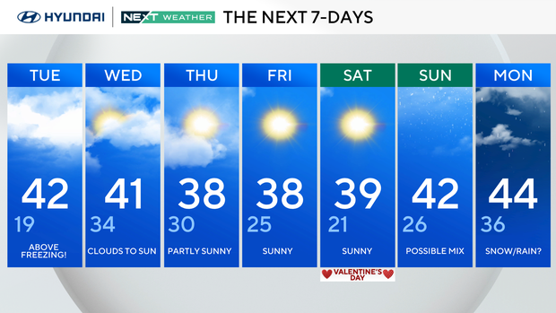
Tuesday: Above freezing. High 42, low 19.
Wednesday: Clouds to sun. High 41, low 34.
Thursday: Partly sunny. High 38, low 30.
Friday: Sunny. High 38, low 25.
Saturday: Sunny. High 39, low 21.
Sunday: Possible mix. High 42, low 26.
Monday: Snow, rain? High 44, low 36.