Snow, Rain On The Way
By Katie Fehlinger
PHILADELPHIA (CBS) -- Many of us will head to bed Wednesday night with rain tapping on our windows. But a choice few counties will wake up to a thin blanket of snow Thursday morning!
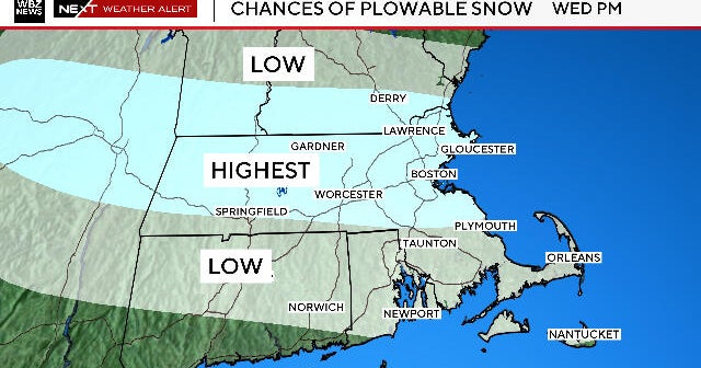
It'll all happen fast. A storm is set to develop to our southwest over the Carolinas and quickly intensify as it heads our way Wednesday. The system is mainly going to be a rainmaker, with a general soaking across the region through the day. But Mother Nature's got perfect timing on this one. The changeover from rain to snow will occur between midnight and 3 a.m. Wednesday night into Thursday - when temperatures will be dropping to levels cold enough for snow. The storm won't have much time - only a few hours - but the several hours when it WILL snow will allow a few wimpy inches to accumulate. Let's break down the expectations:
Accumulations:
- 1-3" from Lancaster to Northampton counties.
- Coating to an inch for northernmost New Castle County, DE to Mercer County, NJ (Center City Philly included).
- Just rain for southern New Jersey and central DE.
**Very important to note: this is NOT a repeat of the now infamous October 2011 snowstorm. Although the snow coverage area will be very similar, the storm is moving faster and we won't have as much accumulation. Perhaps most importantly, the snow won't be as heavy nor as wet. Therefore, it won't pose as much of a threat to power lines and tree limbs.
Nonetheless, it's a good idea to plan ahead for slow, slushy, slippery morning travel for the Thursday commute.