Blizzard dumps over a foot of snow around Philadelphia region, 14 inches reported at PHL Airport

All winter storm and blizzard warnings in the Philadelphia area have been canceled after a major storm dumped over a foot of snow across the Delaware Valley.
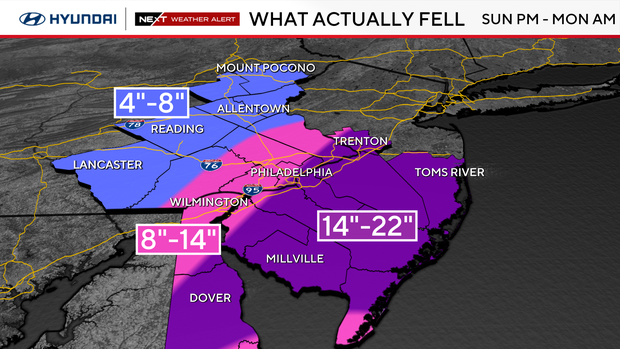
The "Blizzard of '26" is officially our biggest storm in over a decade. As of 1:30 p.m., Philadelphia International Airport reported 14 inches of snow. This puts us at nearly 30 inches of snow this winter, catapulting 2025-2026 into the top 20 snowiest winters on record in Philadelphia and the snowiest since 2013-2014. And it's not even March yet.
A NEXT Weather Alert remains in effect around the Philadelphia area because of the lingering snow and the chance for things to freeze up overnight. We'll have to watch for black ice on the roads, and anything unplowed will be icy Tuesday morning.
The storm intensified overnight offshore and brought bands of snowfall with rates of more than 2 inches per hour. The "jackpot zone" ended up over Lower Bucks County, where totals exceeded 20 inches in many spots.
Tuesday is sunny but cold with highs only barely above freezing and a gusty wind.
When's the best time to shovel snow?
Temperatures will warm slightly into the mid-to-upper 30s on Monday, so the wet snow will remain relatively soft. The NEXT Weather Team recommends spending the time clearing off your driveway, walkways, etc., before it hardens up a bit Monday night into Tuesday.
Be very careful with this heavy, wet snow. It's called "heart attack snow" for a reason.
How much snow did we get so far?
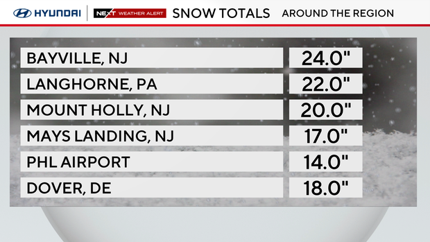
Over a foot of snow has been reported in cities across Pennsylvania, New Jersey and Delaware.
Some of the biggest totals were recorded in Langhorne, Pennsylvania (22 inches), Morrisville, Pennsylvania (21 inches), Mount Holly, New Jersey (20 inches), Lake Pine (18 inches) and Ocean City, New Jersey (14 inches).
Philadelphia International Airport reported 14 inches as of Monday afternoon.
NEXT big weather changes
A NEXT Weather Alert will be in effect on Thursday because of the possibility of rain and snow showers later in the day. While accumulations look light now, the timing could help produce a few inches. The NEXT Weather team will be monitoring the forecast.
Next weekend in the Delaware Valley looks sunny and mild in the low 50s.
Here's your 7-day forecast:
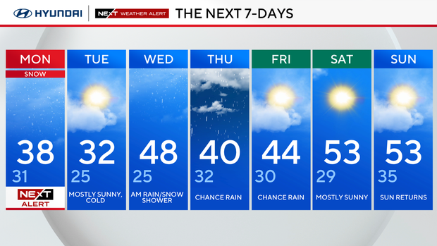
Monday: NEXT Weather alert for snow. High 38, low 31.
Tuesday: Mostly sunny, cold. High 33, low 25.
Wednesday: A.m. snow, rain shower. High 48, low 25.
Thursday: NEXT Weather Alert for rain and snow. High 40, low 32.
Friday: Chance rain. High 44, low 30.
Saturday: Mostly sunny. High 53, low 29.
Sunday: Sun returns. High 53, low 35.


