Snow, ice bring dangerous travel conditions in Philadelphia area Friday — timing and snow totals


You'll want to stay off the roads Friday evening and overnight into Saturday because a strong winter storm is approaching the Philadelphia region.
A NEXT Weather Alert is in effect from 3 p.m. Friday through 10 a.m. Saturday because of potentially dangerous weather.
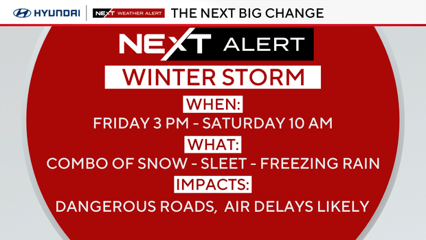
A winter storm warning is in effect for the Poconos and parts of the Lehigh Valley, and a winter weather advisory is in place for the remainder of the Philly area and much of Pennsylvania, New York and West Virginia.
Here are the most important things to know about this storm:
- The threat of freezing rain and ice is what makes this system so dangerous.
- This begins in our area after 3 p.m. Friday and ends between 6 and 10 a.m. Saturday. (Warnings for the western part of the state begin at 10 a.m. Friday.)
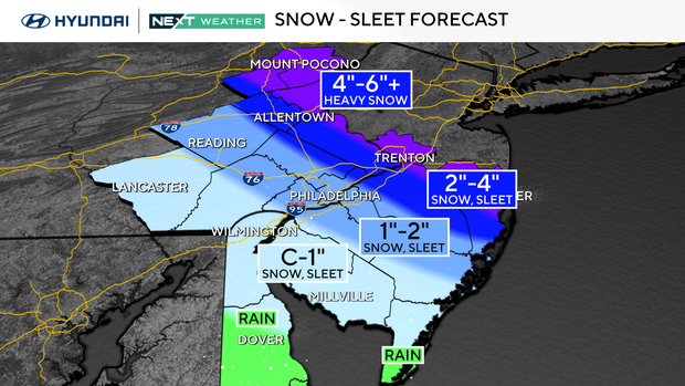
- The heavier snow line has shifted slightly north. However, depending on where you live, there could be heavy snow, a snow/sleet combination, a snow/freezing rain combination, or mainly rain with wet snow.
- The precipitation may start as all snow, except in southern Delaware and South Jersey, which will get rain.
- In Philly, precipitation will shift between snow, sleet and freezing rain.
- Any snow totals will include both the sleet and snow.
- The heaviest snow will be north of a line from the Lehigh Valley to North Jersey and New York.
- Philly, Southeast Pennsylvania and parts of South Jersey are on the edge of the snow/sleet line with shoveling snow possible.
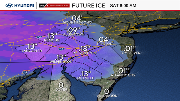
- Roads across the region will be dangerous in places from either snowpack or up to 0.2 inches of ice.
The messy weather could cause delays and cancellations at the airport as well as delays on trains and buses. Scattered power outages could occur, too.
Snow-sleet totals
These totals will change if the track changes.
- 4–6+ inches (all snow): Parts of the Lehigh Valley, Poconos
- 2–4 inches (snow and sleet): Parts of Lehigh Valley, Northeast Philly, Bucks, Burlington, Mercer counties
- 1–2 inches (snow, sleet, up to 0.2 inch freezing rain): Philadelphia, I-95, Montgomery, Berks, Delaware, New Castle, Gloucester, Camden, Atlantic counties
- Coating–1 inch (snow, sleet, up to 0.2 inch freezing rain): Salem, Cumberland, New Castle, Berks, Chester, Atlantic counties
- Rain: Cape May, Kent counties
Restrictions on the roadways
PennDOT is restricting speeds to 45 mph on these roads because of the weather:
- Interstates 76, 95, 295, 476, 676
- U.S. Routes 1, 30, 202, 422
- State Routes 63, 100 Spur and 309
Some highways also have vehicle restrictions in place because of the conditions. On these roads, the following restrictions are in place: no commercial vehicles are permitted EXCEPT loaded single trailers with chains or approved alternate traction devices; school buses, commercial buses, motor coaches, motorcycles, RVs/motorhomes and passenger vehicles towing trailers (cars, SUVs, pickup trucks, etc.) are not permitted.
- Interstate 81, south of I-83
- ALL Pennsylvania interstates west of I-81 including: PA Turnpike I-76, PA Turnpike I-70, all western PA Turnpike extensions
- I-81, north of I-83
- Route 33, entire length
- U.S. 22 between I-78 to Route 33
- ALL Pennsylvania interstates east of I-81 including: PA Turnpike I-76; all eastern PA Turnpike extensions
PennDOT says restrictions will be lifted as soon as conditions are safe.
In New Jersey, acting Gov. Tahesha Way declared a state of emergency across the state because of the storm.
The New Jersey Department of Transportation also enacted temporary restrictions starting Friday afternoon for tractor-trailers, empty CDL trucks, RVs, motorcycles, and passenger vehicles pulling trailers for I-78, I-80, I-280, I-287, and Route 440.
The state of emergency is in place until officials decide it's no longer needed, an announcement from the governor's office said.
What comes NEXT?
Another storm system on Sunday night will bring rain to the region, followed by another bitterly cold blast next week for the final week of 2025.
Here's your 7-day forecast:
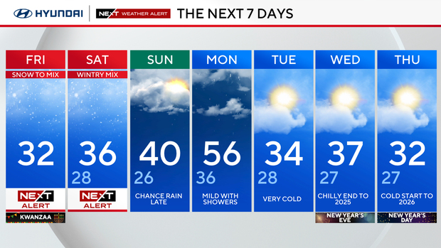
Friday/1st night of Kwanzaa: NEXT Weather Alert for afternoon/evening snow and ice. High 31, low 26.
Saturday: NEXT Weather Alert for morning snow and ice. High 34, low 29.
Sunday: Chance of rain late. High 39, low 28.
Monday: Mild with showers. High 50, low 38.
Tuesday: Very cold. High 34, low 28.
Wednesday/New Year's Eve: Chilly end to 2025. High 37, low 26.
Thursday/New Year's Day: Cold start to 2026. High 32, low 24.