Pleasant summer weather continues through Sunday across Philadelphia region. Here's the forecast.

Finally, a weekend without smoke, storms, record heat, and sweaty conditions in the Philadelphia area. This is a chance to get outside and enjoy, no matter what the activity.
You'll need the sunglasses and sunscreen whether at the Shore, Poconos, or in Center City.
Temperatures in Philadelphia will be at or below average, in the mid-80s, with sunny skies and low humidity. It will be a tad cooler at the Shore courtesy of light east winds off the water.
The extended outlook from the Climate Prediction Center keeps us in this mild temperature pattern through next weekend while record heat builds across much of the nation.
NEXT big weather changes
You knew it couldn't last. Humidity returns Monday with high clouds and scattered afternoon showers and storms. This is all ahead of a system dropping out of the Great Lakes.
A NEXT WEATHER ALERT is currently in effect for Tuesday due to the threat of strong to severe storms. Damaging winds and heavy rain with flash flooding are the risks.
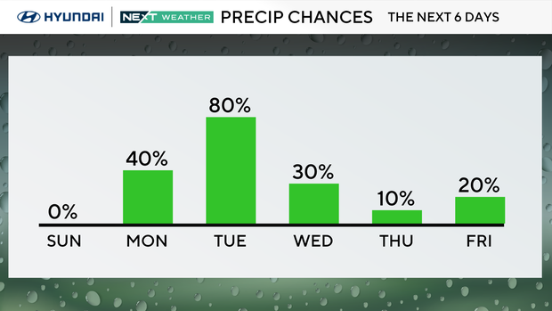
An isolated shower cannot be ruled out.
Wrap-around instability showers and storms are possible on Wednesday as the system slows overhead.
Here's your 7-day forecast:
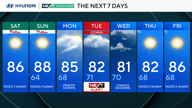
Saturday: Mostly sunny. High 88, low 66.
Sunday: Mostly sunny. High 88, low 65.
Monday: Late-day storm. High 85, low 68.
Tuesday: NEXT Weather Alert day for storms. High 82, low 71.
Wednesday: Few showers. High 81, low 70.
Thursday: Mostly sunny. High 82, low 68.
Friday: Mostly sunny. High 86, low 68.


