Heat wave continues Wednesday before storms, flash flooding and cooler air arrive later this week


Tuesday brought record-setting heat around parts of the Philadelphia area, and PHL recorded a 98-degree high temp, tying the record set in 2002, and we will likely do it again on Wednesday!
But what will it feel like? Along with the increasing temperatures, the humidity will also be on the rise, making it feel like anywhere between 100-105 degrees, perhaps even hotter in spots at times.
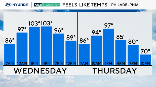
When temperatures climb this high, it can be dangerous for anyone without adequate ways to stay cool and hydrated. As a result, the NEXT Weather Team has issued a NEXT Weather Alert through Wednesday evening.
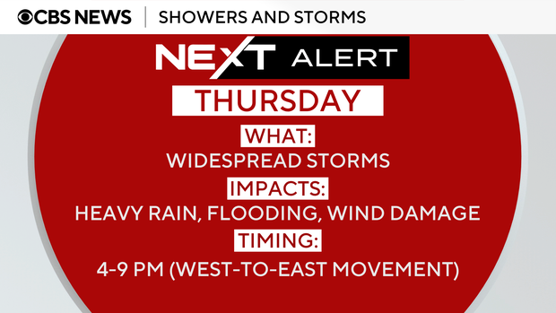
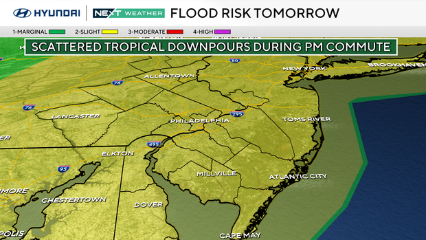
Tropical downpours, flash flood risk for Thursday PM commute
Each of our heatwaves this summer has ended with gusty to strong storms and tropical downpours with flash flooding. That will once again be the case on Thursday as a slow-moving cold front approaches. This has triggered a NEXT Weather Alert for Thursday.
We are in a level 2 of 4 risk of flash flooding and under a flood watch for Thursday. While stray showers and isolated storms are possible Thursday morning, more widely scattered storms will develop after 2pm moving from west to east across the entire area. Philadelphia will see the heaviest rain between 4-8 PM smack dab in the middle of the evening commute. Storms will continue over South Jersey and exit the Jersey shore between 9-10 PM.
With so much moisture in the atmosphere over our heads, any storm could wring out several inches of rain in a short period of time, leading to localized flash flooding on streams, creeks, roadways, and underpasses. Travel delays are possible at PHL. Not all neighborhoods will see the same amount of rain; it's all about location, location, location. Just don't drive through flooded areas. Only 18 inches of water can float most vehicles, and being caught in rushing flood water is often deadly. "Turn Around, Don't Drown" and find a clear route to take.
There is also a low-end risk that a few storms could briefly turn severe with intense lightning and damaging wind gusts. Isolated power outages and downed trees are possible.
Remember "If thunder roars, get indoors." Wait at least 30 minutes after the last boom of thunder or flash of lightning before heading back outside. Stay away from windows and plumbing during a lightning storm, and if outside, seek shelter in a sturdy building or car with windows up. Never stand under trees, bleachers, or in open areas. You don't need to be struck directly by lightning to be injured or killed. A lightning strike spreads out on the ground like spokes on a wheel, hitting anyone in its path. Many times, people and animals are injured this way.
Relief from the heat! Much cooler air is on the way
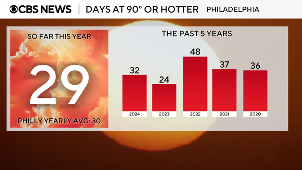
It has been an excruciatingly hot July with 20 days in the 90s and counting. Overall, this summer we have had five heatwaves and recorded 29 90-degree days. Philadelphia's yearly average of 90-degree days is 30, and with more than a month left this summer, we will easily exceed that number.
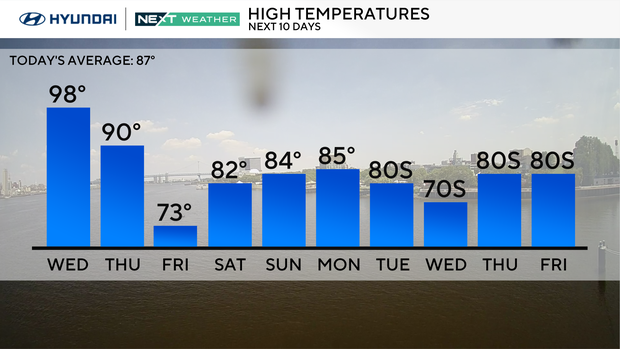
So, when can we expect some relief from the heat? How about Friday, Aug. 1? That is the start of a much-needed and weeklong cool-down.
Gone will be the high heat and stifling humidity, replaced with pleasant, mostly sunny, dry days and below-average highs in the upper 70s to low 80s. Lows will be in the 60's.
A perfect time for fun outdoor plans, and outside work on the house or yard. Pets will enjoy longer walks and the evenings will feel more comfortable. Cooler conditions also mean good sleeping weather and you'll be able to keep the windows open at night.
By the end of next week (the first week of August), high temperatures start leveling off near normal on either side of 87 degrees and that trend will continue through mid-August.
Nationwide, the extreme heat has retreated to the south and southwest, with cooler air arriving in the Pacific Northwest and pleasant conditions across the Mid-Atlantic, including Philadelphia.
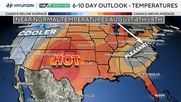
Of course, all good things must come to an end. It is, after all, summer in Philadelphia, so expect the return of more heat and 90s later in August.
Here's your 7-day forecast:
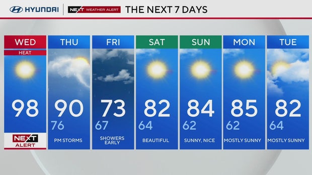
Wednesday: NEXT Weather Alert for heat. High 98, Low 78.
Thursday: P.M. storms. High 90, Low 76.
Friday: Shower early. High 73, Low 67.
Saturday: Beautiful. High 82, Low 64.
Sunday: Sunny, nice. High 84, Low 62.
Monday: Mostly sunny. High 85, Low 62.
Tuesday: Mostly sunny. High 82, Low 64.