Breezy Wednesday in Philadelphia region, storms on the way. Here's the weather forecast.
Wednesday's weather in Philadelphia starts mostly cloudy, with some sunshine later on as we await the arrival of rain. It will be breezy with a northwest wind gusting to 20 mph.
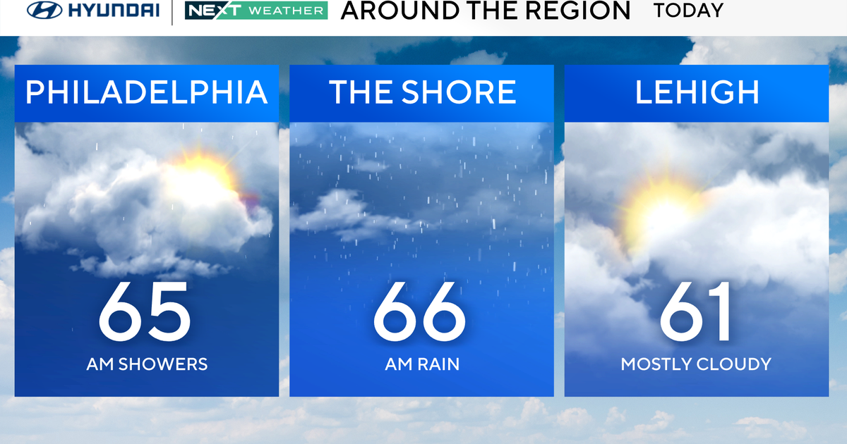
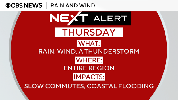
The next impactful storm we are watching will arrive Wednesday night and bring widespread impacts to the Philadelphia region Thursday in the form of wind and rain. We've issued a NEXT Weather Alert for this rain that could impact both the morning and evening commutes and pose a low-end flooding risk.
The flood risk is low because while rainfall totals will be in the 1 to 3 inch range, the rain will be spread over the course of six to 12 hours. That makes flash flooding unlikely, though we will be on the lookout if any arises.
Winds will pick up near the shore, gusting up to 30 or 35 mph, and move across the entire Delaware Valley.
Ponding and localized urban flooding are a possibility. In addition to the heavy rain, a rumble or two of thunder is possible as the Storm Prediction Center has our region under the general thunderstorms category, which means severe weather isn't likely.
The storm system should be out of our area by Friday, opening the door to cooler conditions but dry on Halloween night. It won't be the 80s like we had last year, but it won't be stormy either. That dry weather will likely stay through the weekend.
Meanwhile, Hurricane Melissa continues its trek across the Caribbean, making landfall near Chivirico in eastern Cuba around 3:10 a.m. Eastern TIme. Melissa will impact Cuba through the day and then likely move onto the Bahamas and Turks and Caicos Wednesday night before heading out into the Atlantic.
Just prior to landfall in Jamaica on Tuesday, the central pressure dropped to 892 millibars with sustained winds of 185 mph, meaning Melissa has tied for the third strongest storm on record pressure-wise in the Atlantic basin, and the second for strongest sustained winds in the Atlantic basin.
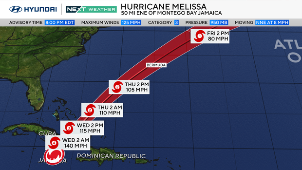
Only six storms in the Atlantic previously have dropped below 900 millibars, with the strongest being Wilma in 2005, which had a central pressure of 882 millibars. It's also important to note that these are the stats at landfall, while other storms achieved this status over open water. These stats at landfall would tie with the 1935 Labor Day hurricane as the strongest to come on shore.
The weekend is looking dry and seasonably mild. Don't forget THIS SUNDAY, we set the clocks back one hour, meaning the sun will rise on Sunday morning at around 6:30 a.m. but set at 4:56 p.m. Yes, the 4 p.m. hour until Jan. 15, when it will then set at 5 p.m.
Stay with your NEXT Weather Team for the latest.
Here's your 7-day forecast:
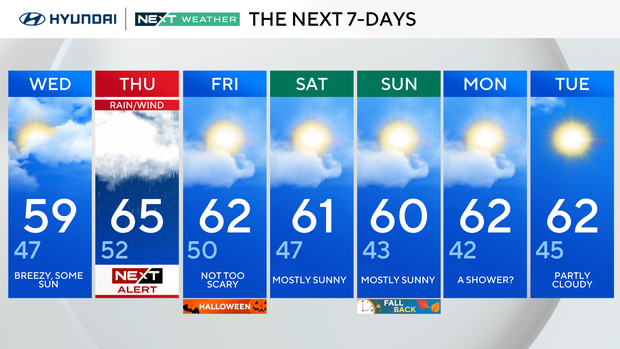
Wednesday: Breezy, some sun. High 59, Low of 47.
Thursday: NEXT Weather Alert for rain and wind. High 65, Low 52.
Friday/Halloween: Not too scary. High 62, Low 50.
Saturday: Mostly sunny. High 61, Low 47.
Sunday: Mostly sunny. High 60, Low 43.
Monday: A shower? High 62, Low 42.
Tuesday: Partly cloudy. High 62, Low 45.