Potential snow, wintry mix Sunday triggers winter storm watch in Philadelphia area. Here's the weather forecast.
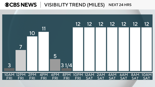
The heavy morning rain has moved out of the Philadelphia area, but Friday will remain cloudy and damp throughout the day, with potential areas of dense fog forming this evening and clearing out overnight.
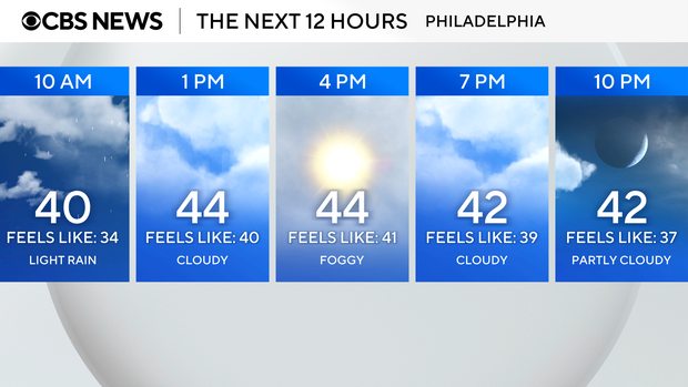
We've issued a NEXT Weather Alert for the fog today.
Separately, we have another NEXT Weather Alert Sunday into Monday, as we continue tracking the chance of slushy, accumulating snow or wintry mix as a coastal low approaches.
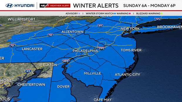
The entire Delaware Valley will be under a Winter Storm Watch from 6 a.m. Sunday through 6 p.m. Monday due to heavy snow, with total snow accumulations exceeding 6 inches possible, and winds could gust as high as 35 mph.
NEXT big change
Some sun returns Saturday with a high near 50 and then another big change. A coastal low will develop Sunday, coinciding with the return of colder air.
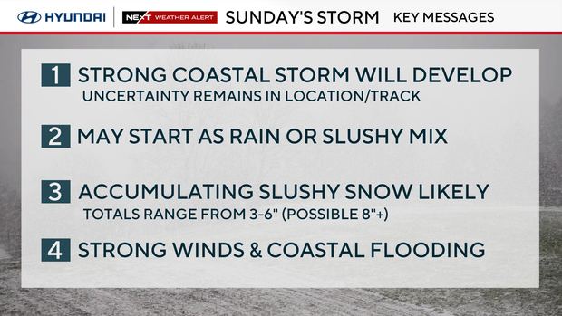
What we know: There will be a coastal storm Sunday, and colder air will arrive as it forms.
What we need to determine: The position of the low relative to the coast. If the low forms close to the coast and throws moisture into our area Sunday night, with surface temps below freezing, we could be looking at some significant snow.
The GFS model continues to stick to this scenario consistently in each run. Most of our other models were keeping the center of the low focused a bit farther offshore, but more recent runs Friday afternoon are bringing it closer to the coast, making snow for most of us look more likely.
As an additional wild card, many try to introduce a dry slot over the city, which could limit totals.
As of now, the most likely scenario appears to be several inches of slushy snow for most, with a bullseye or "jackpot" zone for areas closest to the coast that will get in on some of the convective snow bands Sunday night as the storm rapidly strengthens.
These areas could be looking at over 6 inches of heavy, wet, pasty snow, in addition to some coastal flooding and strong winds. If the center of the low strengthens closer to the coast, the jackpot zone moves inland; if it's further out to sea, that zone shifts out over the ocean.
How much snow will we get?
To keep you updated, we've created a "first call" map with some preliminary snow totals that we could receive. This storm is still on its way and these numbers can and likely will change between now and Sunday.
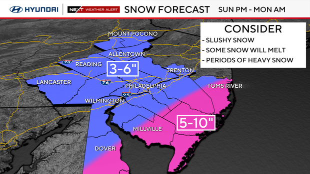
It's important to note that most, if not all, of the accumulation will likely happen after 8 to 9 p.m. Sunday, because even though it may be snowing during the day, it'll have a tough time accumulating with temperatures near 40 and some mixing. We have to wait for the combination of overnight cold and the strengthening storm before snow will start to pile up.
The storm could also bring strong winds, which will be heaviest along the coast, and could present coastal flooding concerns.
We will continue to keep an eye on this storm as it develops and keep you updated. Stay with the NEXT Weather team for the latest.