Philadelphia weather: Tracking another 4-6 inches of snow Friday

PHILADELPHIA (CBS) -- Temperatures rebounded slightly Thursday after a stretch of brutally cold days, but more snow is coming to Philadelphia and the region Friday.
Thursday was relatively quiet around the Delaware Valley, with slightly warmer temperatures and lighter winds. Conditions remained cloudy with highs near 35 and feels-like temperatures in the upper 20s.
It was the calm before the storm as another round of snow moves in Friday with the potential for several inches of accumulating snow.
Snow timing
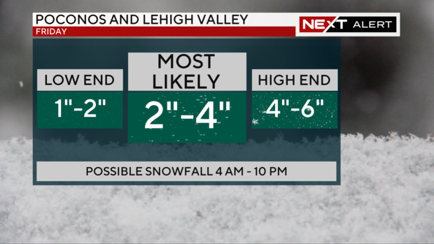
Light snow will begin to spread across the area between 4 a.m. and 6 a.m. Pockets of steadier snow will develop from 6 a.m. to 9 a.m., with the steadiest snow likely coming down between 9 a.m. and 3 p.m. Snow should taper off by the evening.
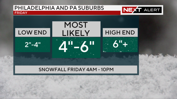
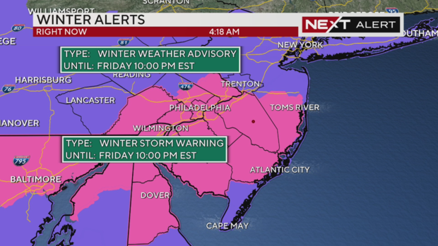
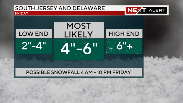
A Winter Storm Warning will be in effect from 4 a.m. until 10 p.m. Friday, with four to six inches of snow expected in Philadelphia and along the I-95 corridor, and a CBS Philadelphia NEXT Weather Alert will be in effect throughout the day due to the snow.
RELATED: Rock salt vs. ice melt: Which is best for icy sidewalks in Philadelphia region?
How much snow in Pa., NJ and Del.?
Four to six inches of snow is expected across the region. This comes on the heels of Tuesday's system that dropped more than three inches in Philadelphia -- and ended the city's nearly two-year-long snow drought.
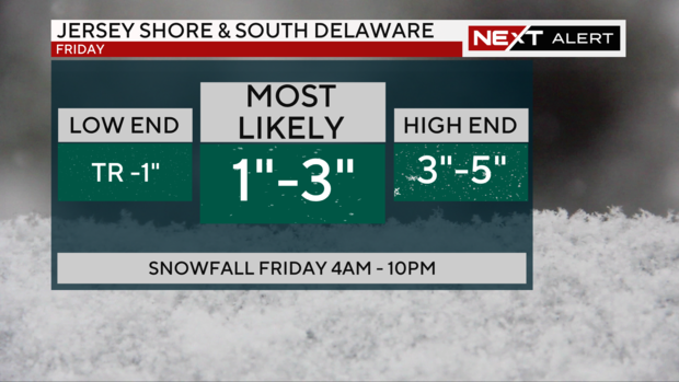
The shore points, which could experience some rain and snow mixing, are looking at one to two inches of snow.
While not a "massive" snowstorm, according to meteorologist Kate Bilo, the timing of the system will likely impact both the morning and evening commutes.
Weekend outlook
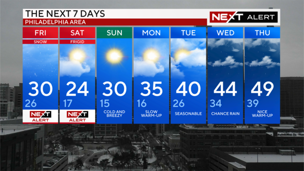
More cold air follows Friday's system, so Saturday will be very cold and windy again. Winds could gust to 30 mph and wind chills will struggle to get above single digits.
In Philadelphia, it'll feel like just 2 degrees; in Mount Pocono, it'll feel like -10.
A NEXT Weather Alert remains in effect Saturday, though in this case because of the cold.
Sunday stays dry but breezy and cold again, so you'll need the heavy winter gear through the weekend, but temperatures will start to rebound by Tuesday.
7-day forecast
Thursday: High of 35, cloudy and not as cold
Friday: High of 32, low of 28, NEXT Weather Alert for snow
Saturday: High of 24, low of 17, NEXT Weather Alert for cold
Sunday: High of 30, low of 18, frigid start
Monday: High of 35, low of 17, mostly sunny
Tuesday: High of 42, low of 27, back to the 40s
Wednesday: High of 45, low of 32, chances for rain
Get the latest weather info on the CBS News Philadelphia app.


