Below-freezing temps stick around in Philadelphia as coastal storm threat diminishes. Here's the forecast.
Our below-freezing stretch in the Philadelphia region continues on Friday, making it the seventh consecutive day with a high temperature below 32 degrees.
We have not been above freezing since 7 p.m. on Friday, Jan. 24, currently about 159 hours and counting — but who's counting?
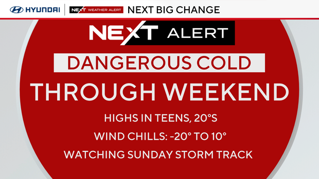
The record low temperature for Jan. 30 is 7 degrees, and while we might not get that low, it will be close. High temperatures will stay in the teens and with the wind chill, it will feel like it's about 5 degrees.
We've been in a rare stretch of consecutive days of cold weather. It hasn't been this cold, for this long, in a while. Thursday marked the sixth day, making it the longest stretch since 2018, when we had seven days below 32 degrees.
After Friday, it will be the longest stretch since 2004, when we had nine days below freezing.
Once we get to Sunday (nine days), it will officially be the longest consecutive stretch since 1979 — nearly 50 years! Needless to say, temps this cold for this long don't happen too often here in the Philly area.
Temperatures will likely not get back above freezing until Tuesday of next week, marking 10 days of subfreezing temps. We've only had subfreezing streaks longer than that six times since records have been kept, with the record being a 15-day stretch in 1979.
NEXT big weather change: Arctic air continues, monitoring the Bomb Cyclone
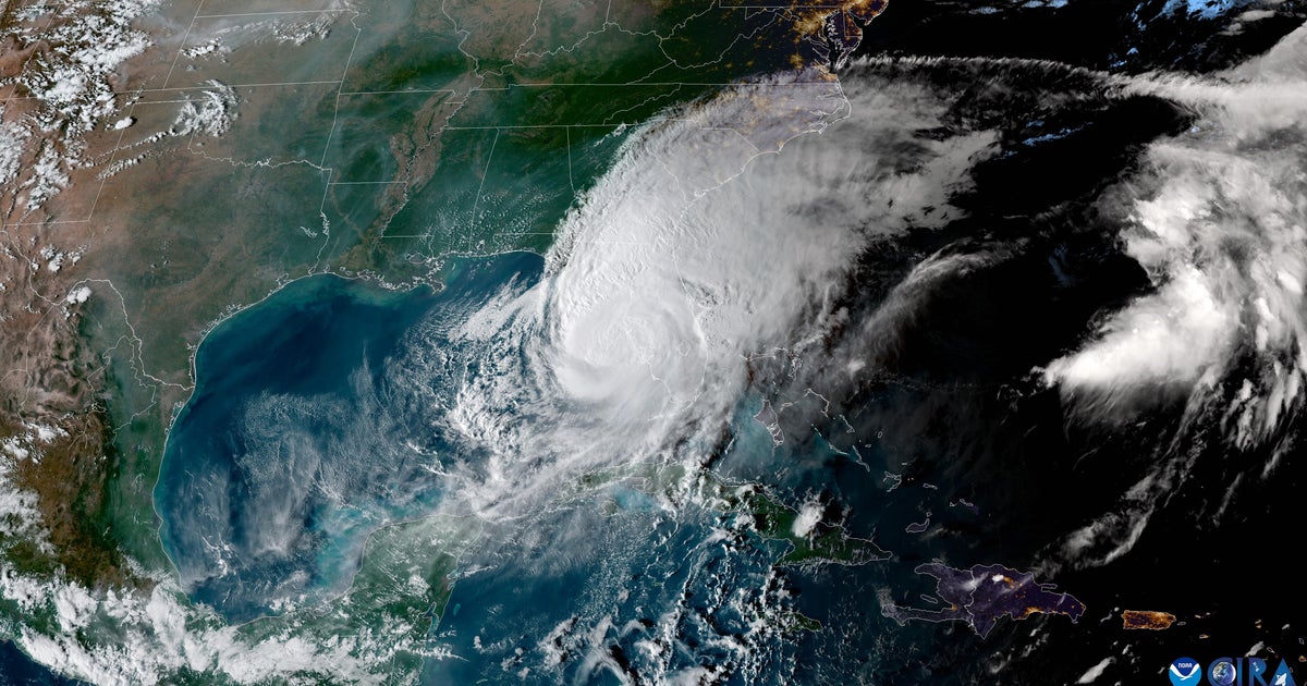
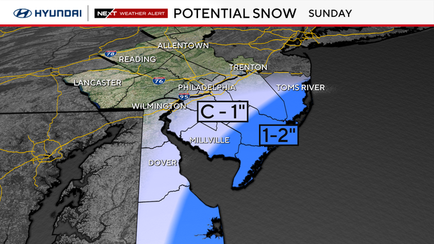
In addition, we are watching a major coastal storm this weekend. Good news, as we continue to dig out from this past weekend's storm, is that the Sunday forecast model tracks continue to push the storm a bit farther east, taking the big snow potential with it.
As of now, the most likely scenario is that the storm will keep most accumulating snow potential south of us and track far enough out to sea that we'll just see maybe a light coating of snow along the immediate coast, but nothing inland. Winds will be the bigger issue there as the storm rapidly intensifies offshore.
While the track could still shift, it's looking more and more unlikely that we see any snow in most of our area.
This is a completely different type of system from what we saw this past Sunday. With the track well off to the south and east, this will be all snow for anyone who gets precipitation. If the snow does make it into the city, it would likely be more reminiscent of two Sundays ago, when it snowed lightly all day and accumulated a few inches at most.
Regardless of the storm's track, it is expected to become what's known as a "bomb cyclone" — a term given to a non-tropical cyclone that undergoes a process known as bombogenesis, which is defined as a rapid decrease in pressure over a short period of time.
In our region, the generally accepted definition is a loss of 24 millibars of pressure over 24 hours. When a storm loses pressure, it's an indication of strengthening, so bombogenesis at its core means rapid strengthening or intensification.
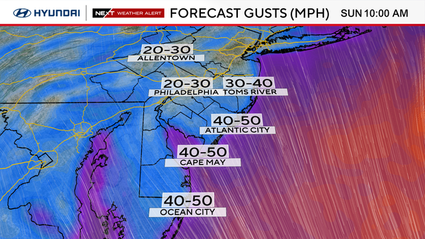
Because of the very strong low off the coast, we also have to mention other coastal impacts. Even if the snow stays out to sea, we can expect wind gusts up to 50 mph along the coast and the threat of coastal flooding, thanks to the ocean water being pushed toward the coastline.
The best advice is to stay with the NEXT Weather team for frequent updates each day to plan and prepare for the weekend.
Side note — if you're wondering if there is a big warmup in the extended forecast, the answer is no.
The longest forecast model goes out to Valentine's Day weekend and isn't showing any considerable warming at this point. Hopefully, it changes and we can get some melting help from Mother Nature.
Here's your 7-day forecast:
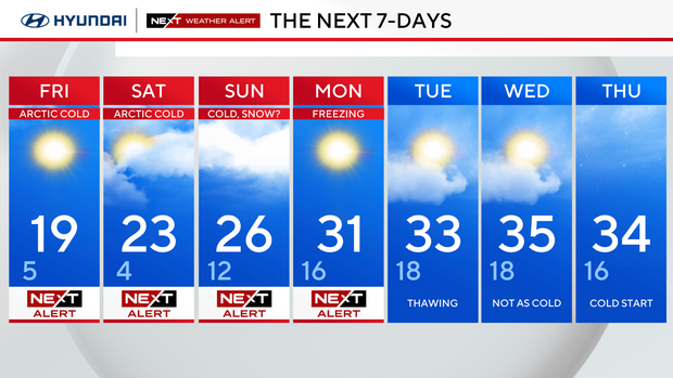
Friday: NEXT Weather Alert for Arctic cold. High 19, Low 5
Saturday: NEXT Weather Alert for Arctic cold. High 23, Low 4
Sunday: NEXT Weather Alert cold, snow. High 26, Low 12
Monday: NEXT Weather Alert freezing. High 31, Low 16
Tuesday: Thawing out. High 33, Low 18
Wednesday: Not as cold. High 35, Low 18
Thursday: Cold start. High 34, Low 16